
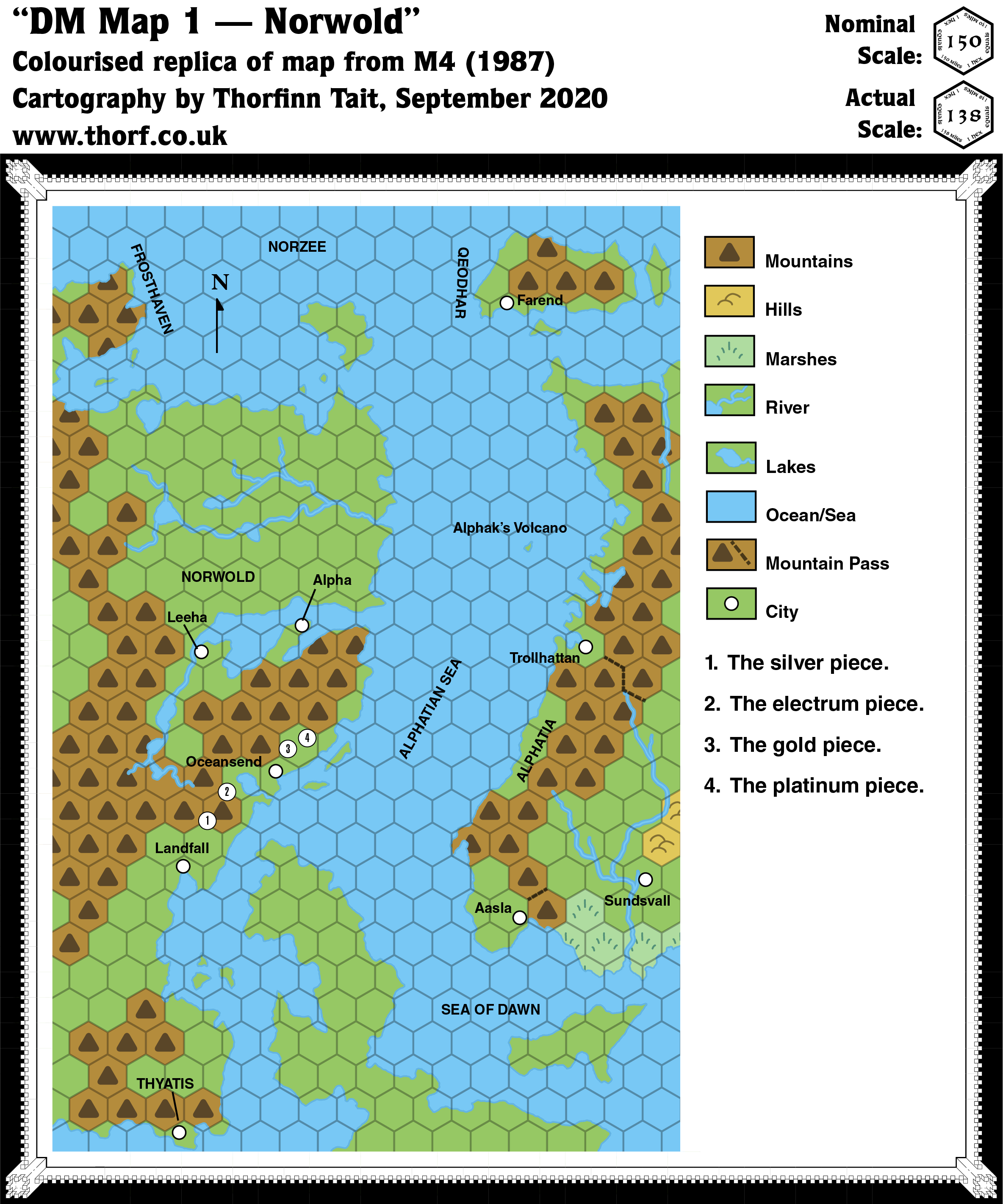
M4 Norwold, 150 miles per hex
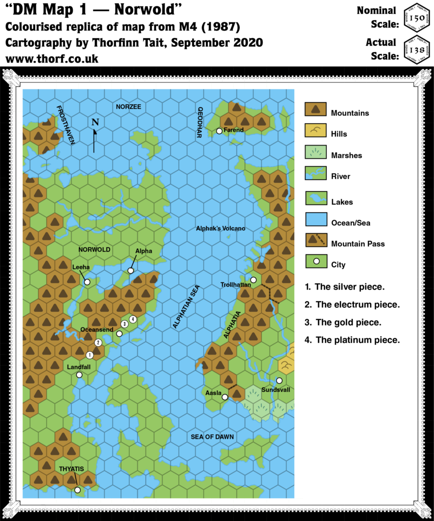
M4 only included one hex map of note, which was itself a straight up reprise of M1’s map. In fact, there are only two differences: the locations of the coins, each of which links to a much larger scale encounter map; and the small lake and river west-southwest of Oceansend, which is unique to this map.
The coin encounter maps are mostly too large scale to be relevant, and therefore outside the remit of the Atlas of Mystara.
The lake is rather more interesting. This lake only appears on this map, and on no other before or since; even later fan-made maps have either overlooked or disregarded it. And yet there it is, clear as day. Given the relative sparseness of detail in Norwold’s maps, it could make for a nice addition to maps of Norwold. Unfortunately, no mention is made of it in M4’s text, and it remains unnamed.
Replica Map (September 2020)
Sources
- M4 Five Coins for a Kingdom (1987) (PDF at DriveThruRPG)
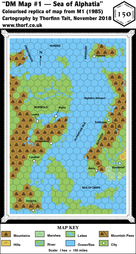
- “DM Map 1”, page 2 (Cartography by William Reuter, based on M1 map by Dave LaForce)
Chronological Analysis
This is Map 56. It was published in June 1987. The updated version of this map has not yet been released. See also Appendix C for annual chronological snapshots of the area. For the full context of this map in Mystara’s publication history, see Let’s Map Mystara 1987.
The following lists are from the Let’s Map Mystara project. Additions are new features, introduced in this map. Revisions are changes to previously-introduced features. Hex Art & Fonts track design elements. Finally, Textual Additions are potential features found in the related text. In most cases, the Atlas adopts these textual additions into updated and chronological maps.
Additions
- Lakes — An unnamed lake has been added west-southwest of Oceansend, connected to the sea by a short river. Up until now this area had been blank terrain, and therefore presumed to be forested (as per CM1). The larger scale map showed a volcano in this region, but the scale of this map is far too small to allow to appear here.
Textual Additions (M4, June 1987)
- Lairs — Encounter 1 is the lair of Dominagon the Blue, a huge blue dragon that “dwells in a large dark cavern”, a “cavernous lair in the cliffside” (M4 pages 5c and 6c). Location 2 is the home of a family of Sphinxes (M4 page 7c).
- Planes — The Outer Plane of Eloysia. The plane is described in detail on pages 12ab and 26-27. It is filled with “quintillions of cubic light-years of weird, semi-solid, gray material” called “the plenum”. The laws of physics are rather different from the Prime Plane. Solar system-sized pockets “play host to whole civilisations”. Eloysia is the name of the plane, but it’s also given as the name of the “pocket” that appears in M4. It is “a colossal, hollow sphere filled with breathable air and lit by a small central sun. Around the sun, thousands of large, rocky islands proceed in stately orbits — not in belts, like the asteroids of our own solar system, but in concentric shells, like electrons around the nucleus of an atom. Some islands are practically dust-motes hardly a mile across. Others are as big as states or nations. Every few millennia, a shard of the plenum, at the boundary of the sphere, is baked solid by the sun’s heat; it breaks free and drifts inward to join the other islands in their orbits.” These islands resemble cornflakes in shape. “The inner side of the island always faces the sun; the inhabitants of all islands live in perpetual noon. The underside miles beneath is dark and lifeless. As for the interior of each island, who knows what creatures live there?” (All M4 page 12ab) Known kingdoms include Trann, Volde, as well as “other kingdoms”. (M4 page 2a) Each kingdom is “a floating island in its own orbit” (M4 page 40b). The islands around Eloysia’s sun are arranged in “three concentric shells”. The inner shell, “hardly more than 10,000 miles from the sun”, is too hot for human life but rich in minerals, which “the Eloysians sometimes mine”. The next shell is the “farm belt”, which is “several thousand miles further out”. It is filled with “lush, green farm-worlds”, “warm, agricultural islands” filled with “fields and vineyards”. These are “watered by vast, permanent rainstorms”. Finally, the “outermost shell” is “about 2,000 miles beyond the farm belt”, and this is where Eloysia’s “many island kingdoms” are located, in “a bewildering diversity of nations and cultures”. (All M4 page 12ab)
- Planets — The world of Mystara is referred to as “Earth” (M4 page 37c). Page 35 provides information about the Sun.
- Rulers — Although most of the characters in M4 are associated with the Outer Plane of Eloysia, the pregenerated PCs provide a couple of points of interest. I’ve included both below, although Eloysia remains beyond the remit of the Atlas of Mystara for now.
- Hogun of Rockhome is “second-in-command under King Everest”. (M4 page 22a)
- Sir Theobold Redbeard, ruler of the city of Lighthall and its dominion.
- The Kingdom of Trann in the plane of Eloysia is governed by five “Ruling Wizards”, who are “old beyond memory” and “maintained their vigour through diligent research into the most profound mysteries of magic. (M4 page 2a) The Ruling Wizards “have ruled their kingdom of Trann together for over a hundred years.” Their names are Dyan (“informal leader of the group”), Jacaine, Saybrook, Kendall, and Warrick. (M4 page 40a)
- Durhan the Conqueror rules the Kingdom of Volde in the plane of Eloysia (M4 pages 2a, 40bc).
- Settlements — The text provides a couple of new settlements:
- Lighthall is a city “situated on the coast of Norwold, about half-way between the cities of Landfall and Oceansend”. It is named “for its well-lit stronghold”. (M4 pages 2c, 3a) Two of the coins are said to have landed “toward a range of cliffs nearby” (page 4a), suggesting that Lighthall should be placed on the coast close to coins 1 and 2 on the map.
- Whitehall is the “great city” where Theona of the Righteous Glory has her church. Location unknown, but likely somewhere in Norwold. (M4 pages 19b, 20b)
Analysis
Other than the lake, there is nothing of particular note on this map. The numbered “coin” labels all connect to much larger scale maps. Only M4 Lake Ashtagon, 1 mile per square is of any geographic significance.
")

")