
Ramelin’s Borean Valley, 8 miles per hex
Following his flurry of maps in July 2017, Jose returned with more new maps in September. This was his first independent map of the Borean Valley, although he had already mapped out most of it as early as January 2016 on the edge of version 2 of his Northeastern Brun map. Later versions of that map cropped it out, preferring to focus on the Norwold area. The Borean Valley is integral in connecting eastern and western Brun maps, so he released it as a separate map of its own, taking the opportunity to update it a little at the same time.
I’m not entirely sure what Jose’s sources were for this area. I assume Matthew Fleet’s 24 mile per hex map had a strong influence, as I’m sure did DJ Shade’s. However, those do not account for all of the details. It seems likely that Jose added his own developments to the area — especially since his was the first map of it at this scale.
Fan-made Map by Jose Ignacio Ramos Lomelin (September 2017)
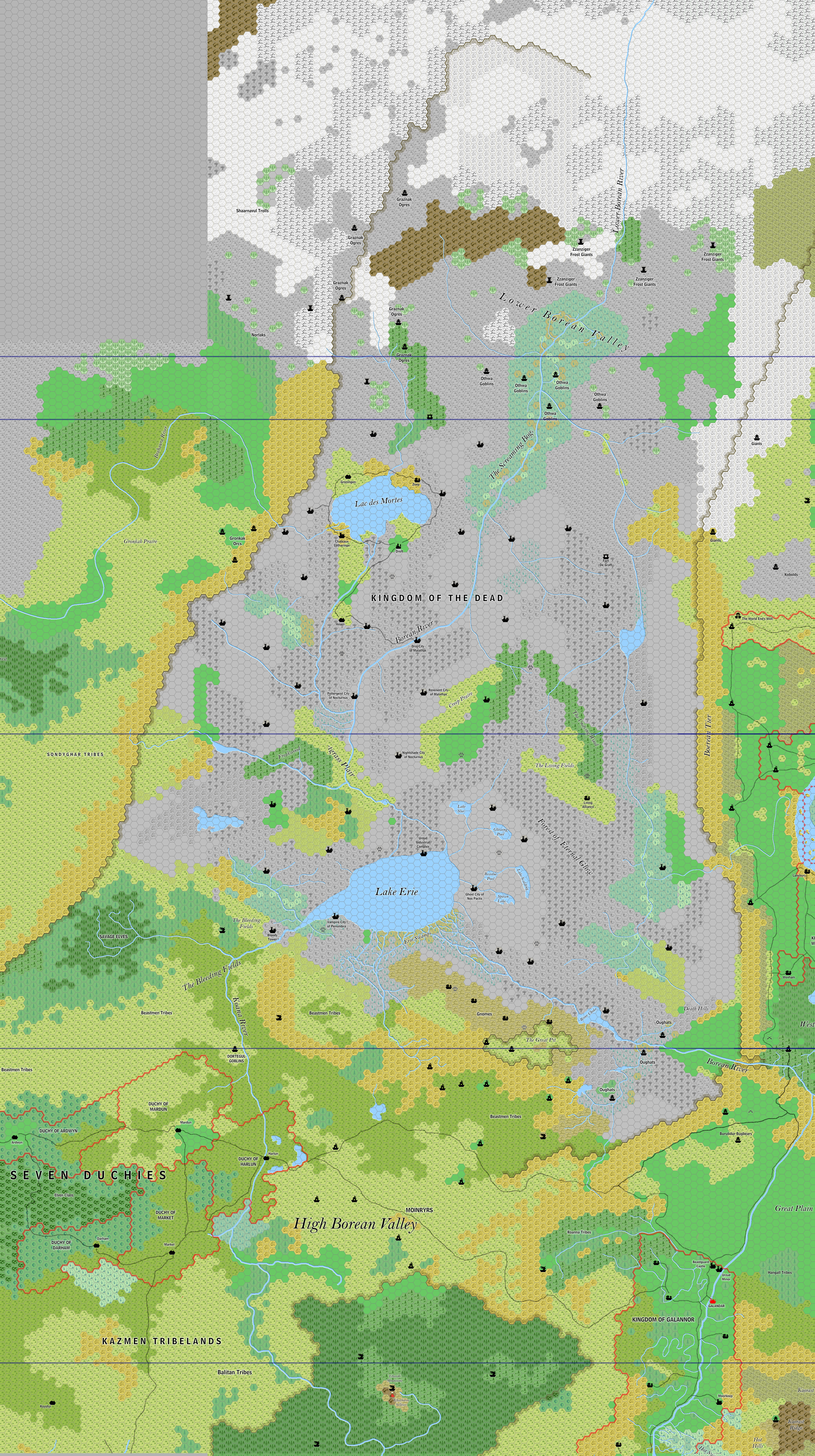
by Jose Ignacio Ramos Lomelin, September 2017
This is an original map created by one of Mystara’s excellent fan cartographers. For more information on the cartographer, including a gallery of all their maps, see also Appendix M: Mappers of Mystara.
Sources
Fan Sources
- The High Borean Valley and the Midlands by Matthew Fleet at the Vaults of Pandius (July 2014)
References
- All of Jose’s maps at the Atlas of Mystara
- Jose’s entry in Appendix M: Mappers of Mystara (upcoming)
- Jose’s author page at the Vaults of Pandius
Chronological Analysis
This is a fan-made map. It was published in September 2017. The updated Atlas version of this map is not yet available. See also Appendix C for annual chronological snapshots of the area. For the full context of this map in Mystara’s publication history, see the upcoming Let’s Map Mystara 2017.
The following lists are from the Let’s Map Mystara project. Additions are new features, introduced in this map. Revisions are changes to previously-introduced features. Hex Art & Fonts track design elements. Finally, Textual Additions are potential features found in the related text. In most cases, the Atlas adopts these textual additions into updated and chronological maps.
Under Construction! Please check back again soon for updates.
Additions
- Settlements —
Revisions
- Settlements —
Hex Art & Fonts
- Hex Art — Ramelin Mystara standard.
- Fonts — Bell MT (major geographic and all water labels), Bell Centennial (all other labels), Feinen (titling).

")
")