
Ramelin’s Yalu Bay and the Yezchamenid Empire, 8 miles per hex
In June 2017, after revising Hule, Jose continued to expand his coverage of Brun. Previously his maps had stopped at Southold and the section of the Arm of the Immortals covered in Dragon #200, but now he moved further northwest to cover the are north of the Arm of the Immortals. Roughly speaking, the northern half of this map was new.
The base for this map was most likely Christian Constantin’s Western Brun, 24 mile per hex map. This was the first time anyone had developed the area at 8 miles per hex, and once again Jose set out to add detail to the terrain. He had already added a few new settlements to Yezchamenid on his previous Arm of the Immortals map, and — uncharacteristically for him — he left these without names.
Originally, Ramelin Mystara had appeared to be going with the continental map for northern Yalu Bay, but this now changed to fit Christian’s map — most likely based on the Hollow World Set world map, as most fan-made maps have done over the years.
Fan-made Map by Jose Ignacio Ramos Lomelin (June 2017)
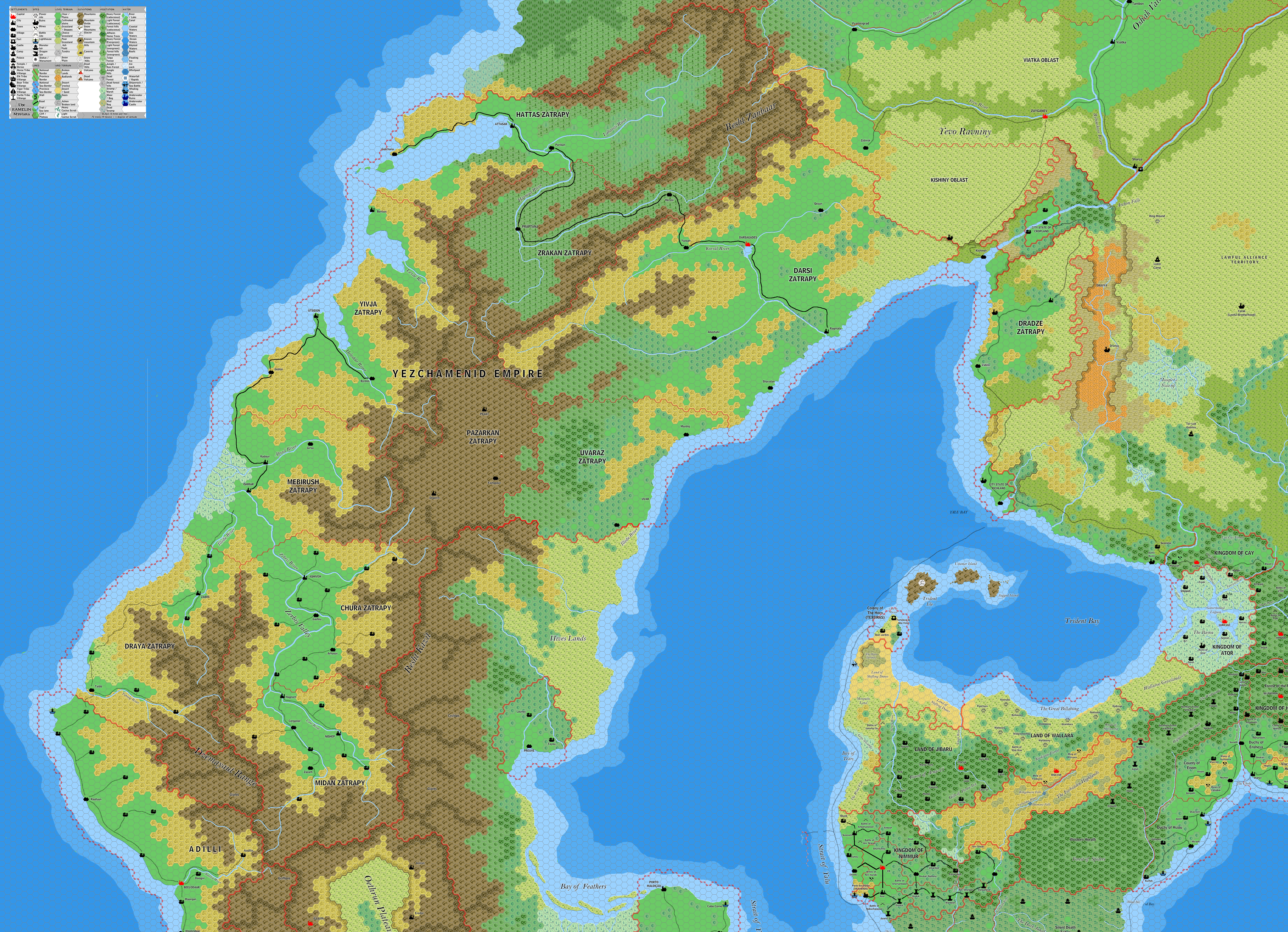
This is an original map created by one of Mystara’s excellent fan cartographers. For more information on the cartographer, including a gallery of all their maps, see also Appendix M: Mappers of Mystara.
Sources
- CM1 Test of the Warlords (1984) (PDF at DriveThruRPG)
- The Known World Grimoire: Lords of the skies, Dragon #200 (December 1993)
Fan Sources
- Christian’s Western Brun, 24 miles per hex (September 1999)
References
- All of Jose’s maps at the Atlas of Mystara
- Jose’s entry in Appendix M: Mappers of Mystara (upcoming)
- Jose’s author page at the Vaults of Pandius
Chronological Analysis
This is a fan-made map. It was published in June 2017. The updated Atlas version of this map is not yet available. See also Appendix C for annual chronological snapshots of the area. For the full context of this map in Mystara’s publication history, see the upcoming Let’s Map Mystara 2017.
The following lists are from the Let’s Map Mystara project. Additions are new features, introduced in this map. Revisions are changes to previously-introduced features. Hex Art & Fonts track design elements. Finally, Textual Additions are potential features found in the related text. In most cases, the Atlas adopts these textual additions into updated and chronological maps.
Under Construction! Please check back again soon for updates.
Additions
- Settlements —
Revisions
- Settlements —
Hex Art & Fonts
- Hex Art — Ramelin Mystara standard.
- Fonts — Bell MT (major geographic and all water labels), Bell Centennial (all other labels), Feinen (titling).


