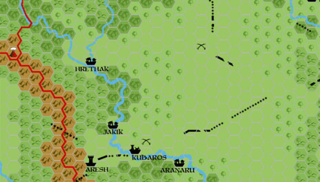
Chimpman’s Aresh Region 2300 BC, 8 miles per hex
John worked up the area around the Citadel of Aresh for a play-by-post game he held in The Piazza forums. This was the first step in development: an excerpt of his Frontierlands v3 map, with some extra settlements and other details marked. The only named settlement in this part of the original map was Aresh itself. Hrethak, Kubaros, and Yidaru were all marked, but unnamed. So all of these names, as well as the other settlements, appeared here for the first time.
It was very much still a work-in-progress, as his comments at the time clearly illustrate:
I’m not quite satisfied with the map yet. I still have 2 more villages to place – they should be nearby but the map is starting to feel crowded. I suppose not all of them could be seen in the 8mph scale.
Hmmm… I may need to up the scale to 2mph and create a more detailed map…
Less than a day after writing this, he posted his new 2 mile per hex map of the area, in which he shuffled around the locations a fair bit.
Fan-made Map by John Calvin (December 2010)
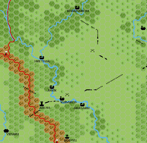
This is an original map created by one of Mystara’s excellent fan cartographers. For more information on the cartographer, including a gallery of all their maps, see also Appendix M: Mappers of Mystara.
Sources
Fan Sources
- Chimpman’s Frontierlands 2300 BC, 8 miles per hex (December 2010)
- [Mystara 2300 PbP] DM’s Thread discussion thread at The Piazza (December 2010)
References
- All of John’s maps at the Atlas of Mystara
- John’s entry in Appendix M: Mappers of Mystara (upcoming)
- John’s author page at the Vaults of Pandius
Chronological Analysis
This is a fan-made map. It was published in December 2010. The updated Atlas version of this map is not yet available. See also Appendix C for annual chronological snapshots of the area. For the full context of this map in Mystara’s publication history, see the upcoming Let’s Map Mystara 2010.
The following lists are from the Let’s Map Mystara project. Additions are new features, introduced in this map. Revisions are changes to previously-introduced features. Hex Art & Fonts track design elements. Finally, Textual Additions are potential features found in the related text. In most cases, the Atlas adopts these textual additions into updated and chronological maps.
Under Construction! Please check back again soon for updates.