Zendrolion’s Mishler’s Midlands
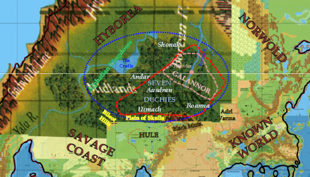
Inspired by a discussion with Matthew Fleet (Carillion) on the location of Galannor, Simone put together this mockup to illustrate his ideas for the Midlands region, and how to reconcile conflicting fan designs for the region. He went into some detail on the map in his post at The Piazza. Here’s a snippet of what he said there:
Just to clarify ideas to myself about Mishler’s Midlands various locations, I made a quick-and-dirty superimposition of labels taken from Mishler’s description over a map of Brun in the latest version released by Thorf. I’ve used only material from Mishler’s Midlands here, not anything from Constantin’s, OldDawg’s, Robin’s, Carillion’s, or Sturm’s maps.
The outlying blue circle should represent the whole Midlands region; the red dashed line represents more or less the “Lands of Law” (including Galannor, the Seven Duchies, and most of the Five Tribes) according to Mishler’s geographical references; the pink dashed line represents instead the approximate area inside which the Kingdom of Galannor should lay. Galandar (old Urzud according to Mishler) has been located “near the headwaters of the Borean River” (as Mishler has it), even if that is not the canonic location of Urzud from GAZ10 (which should be found at the fork of the Borean River, just north of the larger Midlands area. I’ve not placed uncertain locations for which no indication is given by Mishler, such as the dwarven thanedom of Radrast, the Great Pit, or the major elven clans.
All this area, if compared to Constantin’s material about Hule and lands north of it, should be found north of the Kavkaz region, but irrimediably overlaps with Douzbakjian and Sardjikjian. Also, the presence of the massive Ozungan Plateau in Constantin’s version limits the room available for Galannor – which, in the present version of Sturm and Carillion, is found quite isolated on the eastern side of the Plateau itself.
So, instead of pushing the whole setting of Mishler north of that of Constantin, displacing as a consequence most of Mishler’s locations in regard to one another, in my opinion we could attempt to interweave the two settings; this is also possible due to the common inspiration of both – i.e. a “Kingdom/Land of Law” north of Hule which counterbalanced the power of the Temple of Chaos in the hagiarchy. In the future, this will need some work to make Constantin’s and Mishler’s backrgound story of this area fit together, in order to avoid useless duplications or redundant characters or events.
As noted, he used a rough map from my own Lining Up Mystara project as the base, overlaying it with his own details. There has been a lot of fan development in this region, so it’s good to see some attempt to bring things together.
Unless I have missed something, this map was Simone’s last one to date (as of this writing, November 2026).
I’d like to take this opportunity to highlight the wonderful work that he has done for the Mystara community over the years. The highlights were surely his ethnographic, demographic, and historical maps, although there’s no doubt that his most influential map was (and continues to be!) his Norwold map. Simone has produced a highly respected body of maps that have enriched our community as well as Mystaran lore. I hope that he will continue to produce new maps in the future. Thank you, Simone!
Fan-made Map by Simone Neri (February 2018)
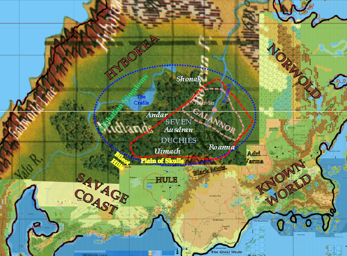
This is an original map created by one of Mystara’s excellent fan cartographers. For more information on the cartographer, including a gallery of all their maps, see also Appendix M: Mappers of Mystara.
Sources
Fan Sources
- The High Borean Valley and the Midlands discussion thread at The Piazza (February 2018)
References
- All of Simone’s maps at the Atlas of Mystara
- Simone’s entry in Appendix M: Mappers of Mystara (upcoming)
- Simone’s author page at the Vaults of Pandius
Chronological Analysis
This is a fan-made map. It was published in September 2013. The updated Atlas version of this map is not yet available. See also Appendix C for annual chronological snapshots of the area. For the full context of this map in Mystara’s publication history, see the upcoming Let’s Map Mystara 2013.
The following lists are from the Let’s Map Mystara project. Additions are new features, introduced in this map. Revisions are changes to previously-introduced features. Hex Art & Fonts track design elements. Finally, Textual Additions are potential features found in the related text. In most cases, the Atlas adopts these textual additions into updated and chronological maps.
Under Construction! Please check back again soon for updates.
Additions
- XXX —
Revisions
- XXX —
Hex Art & Fonts
- Hex Art —
- Fonts —