LoZompatore’s Outer World Precataclysmic Land Differences
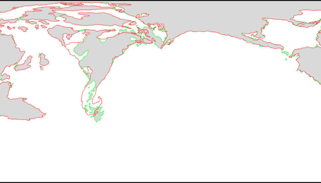
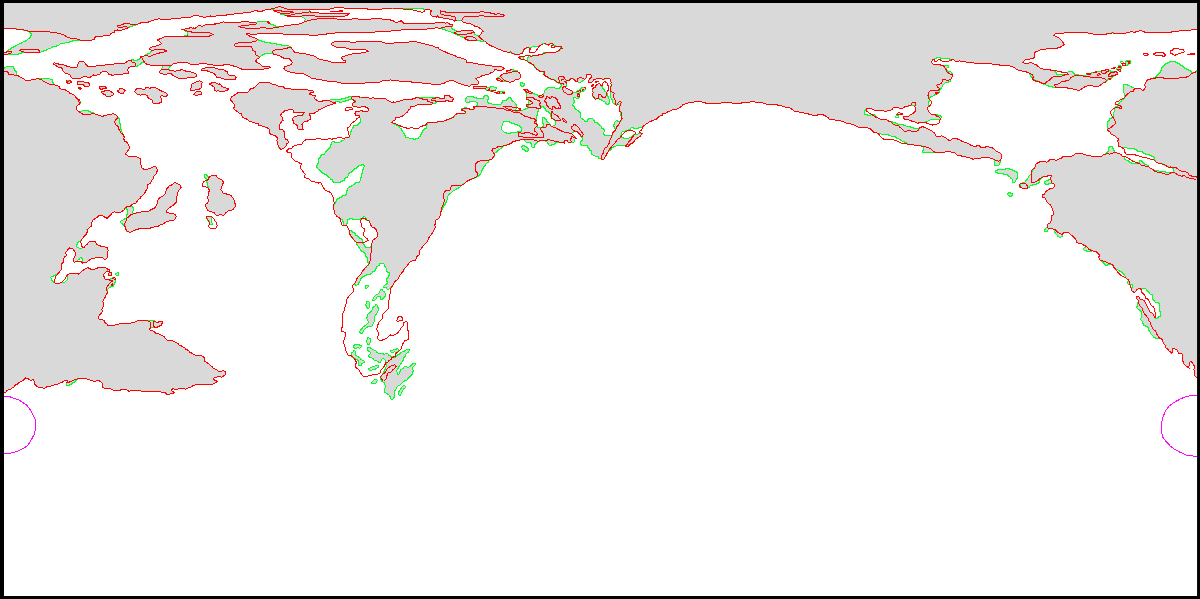
One of a pair of maps from Michele’s Pre-Cataclysmic Mystara article. Using his coastlines map as a base, he worked to incorporate all of the differences in landmasses before the Great Rain of Fire. The primary source for these was Hollow World Set’s Precataclysmic map; though that map was full of problems, it nonetheless provided essential information on the state of the precataclysmic coastlines.
Michele explained:
Now the Hollow World Pre-Cataclysmic map shows a pretty different set of coastlines with respect to Figure 3 above, especially with respect to the whole continent of Skothar, the Known World and the region between Brun and Skothar. Davania and central-eastern Brun are not pretty much modified. Picture below shows the difference between Pre-Cataclysmic (green, with grey landmasses) and Post-cataclysmic (red) coastlines
The main differences were a large number of land bridges joining up modern islands and continents; and a fractured archipelago in place of the Tangor Peninsula, with the island of Zyxl also being much larger.
The sister map showed the exact same details using the modern postcataclysmic map as its base, to make the changes more easily readable for Mystara fans.
Fan-made Map by Michele Carpita (January 2018)
This is an original map created by one of Mystara’s excellent fan cartographers. For more information on the cartographer, including a gallery of all their maps, see also Appendix M: Mappers of Mystara.
Sources
- Master Rules Set (1985) (PDF at DriveThruRPG)
- Hollow World Campaign Set (1990) (PDF at DriveThruRPG)
Fan Sources
- Lining Up Mystara XIX by Thorfinn Tait (February 2016)
- Pre-Cataclysmic Mystara article by Michele Carpita (January 2018)
- LoZompatore’s Outer World (January 2018)
- LoZompatore’s Outer World Ethengar as North Pole (January 2018)
References
- All of Michele’s maps at the Atlas of Mystara
- Michele’s entry in Appendix M: Mappers of Mystara (upcoming)
- Michele’s author page at the Vaults of Pandius
Chronological Analysis
This is a fan-made map. It was published in January 2018. The updated Atlas version of this map is not yet available. See also Appendix C for annual chronological snapshots of the area. For the full context of this map in Mystara’s publication history, see the upcoming Let’s Map Mystara 2018.
The following lists are from the Let’s Map Mystara project. Additions are new features, introduced in this map. Revisions are changes to previously-introduced features. Hex Art & Fonts track design elements. Finally, Textual Additions are potential features found in the related text. In most cases, the Atlas adopts these textual additions into updated and chronological maps.
Under Construction! Please check back again soon for updates.
Additions
- XXX —
Revisions
- XXX —
Hex Art & Fonts
- Hex Art —
- Fonts —