
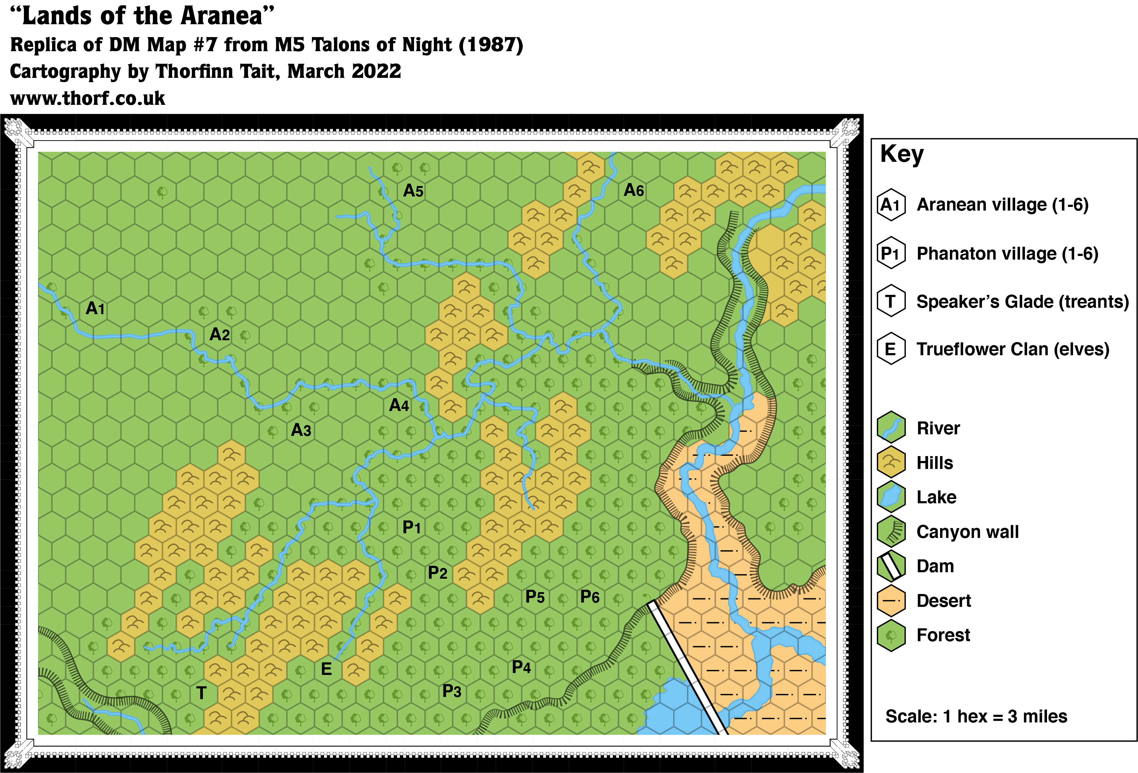
M5 Lands of the Aranea, 3 miles per hex
A detail map of the area above the canyon of the Aurora River, on the Isle of Dawn’s Great Escarpment.
Replica Map (May 2021)
Sources
- M5 Talons of Night (1987) (PDF at DriveThruRPG)
- Page 26 map (Cartography by Dennis Kauth, Steve Sullivan)
Chronological Analysis
This is Map 72. It was published in November 1987. The updated version of this map has not yet been released. See also Appendix C for annual chronological snapshots of the area. For the full context of this map in Mystara’s publication history, see Let’s Map Mystara 1987.
The following lists are from the Let’s Map Mystara project. Additions are new features, introduced in this map. Revisions are changes to previously-introduced features. Hex Art & Fonts track design elements. Finally, Textual Additions are potential features found in the related text. In most cases, the Atlas adopts these textual additions into updated and chronological maps.
Additions
- Rivers — A whole series of tributaries to the Spider River. None of these are labelled on the map, and it’s not clear whether the Spider River (labelled on the Valley of Kings map) is the branch flowing from the north(east), or from the west.
- Settlements — All the keyed settlements on this map are new: six Aranean villages, six Phanaton villages, the elven Trueflower Clan stronghold, and the Speaker’s Glade of the treants. Only the settlement of the treants is named.
- Terrain — The hills marked on this map are new; other maps of the area were presumably too small scale to show them.
Revisions
- Rivers — The course of the Spider River and its tributaries is a little different from the Valley of Kings map. We would expect more detail since this is a larger scale map, but the course of the river differs more than a little. There is also less space between the Temple of the Dawn and the confluence of the Aurora and the Spider rivers.
- Terrain — Whereas the smaller scale Isle of Dawn and Valley of Kings maps left the floor of the Aurora River canyon blank, this map unambiguously marked it with desert symbols. This rather suggests that the whole canyon up to the Temple of the Dawn was intended to be desert, with forests beginning only behind the dam and on the escarpment above the walls of the canyon. Finally, the canyon walls of both the main canyon and the Spider Canyon are slightly different from how they appear on other maps — both the Valley of Kings as well as the much smaller Isle of Dawn map. They don’t line up well, either, so merging them is not an easy task.
Hex Art & Fonts
- Symbols — Hand-drawn symbols.
- Fonts — Helvetica throughout.
Textual Additions (M5, November 1987)
Under Construction! Please check back again soon for updates.
- Rivers — This map features three named rivers and numerous small tributaries. According to the Valley of Kings map, the large river in the southeast corner is the Aurora River, while the smaller but still rather large river flowing into it is the Spider River. So far, so good. What is not so clear is which of the rivers upstream of the fork is the Spider River. Going by the map, we would expect the wider river that continues north and then east off the edge of the map to be the Spider River. However, M5 page 31a splits encounters in this area into those “South of the Spider River” and “North of the river”, with fewer encounters in the south. This suggests that the Spider River is in fact the river flowing from the west past A1. If that is the case, then the other named river, the Red Sabre River (M5 page 20a), must be the wider river shown flowing north and then west off the map. (Page 17a’s Clue 2 also seems to confirm this: “Below the Dawn, there flows a spider, feeder of Aurora. Follow the spider, climb the walls to its lair. Fur friends fight foes.”) To sum up:
- The Spider River flows onto the map from the west, passing location A1 and flowing due east. After location A4, it is joined by four other rivers in succession before cascading over the Spider Falls into a side canyon of Spider Canyon. It then flows gradually down through the canyon, with the Red Sabre River meeting it as it enters the main canyon. Finally it flows southwards into the Valley of the Kings, where it joins the mighty Aurora River.
- The Red Sabre River begins just off the eastern edge of the map (going by the Valley of the Kings map), then turns south and enters the Spider Canyon at its far end through Garsh Falls. It then flows south to join with the Spider River halfway down the canyon.
- Rulers — Minor rulers for this area are mentioned:
- King Choppadigga of the Phanatons above Spider Canyon. (M5 page 30b)
- Elmbeard Longleavesrustlinginthewindatdusk, shaman of the treants above Spider Canyon. (M5 page 30b)
- Clanmaster Trueflower of the Trueflower elves. (M5 page 30b)
- Settlements — The map marks a total of fourteen settlements, denoted in the key. Only one is given an actual name. The text provides some details:
- Phanaton Villages: These villages are “built upon platforms about 50 feet above the forest floor. Although the phanaton can glide from platform to platform, the platforms are connected by rope ladders and bridges. Simple huts on the platforms house family and craft groups. Each village has about 200 occupants.” (M5 page 29a)
- Trueflower Clan: This clan of elves has a “stronghold”, presumably a village of some sort. (M5 page 30bc)
- Speaker’s Glade: This location marked on the map is the “stronghold” of the treants. It’s unclear from the text what form it may take. (M5 page 20bc)
- Aranean Villages: “Only the activity in the trees overhead betrays the presence of the spider village. You snatch glimpses of silk structures strung between tree branches. Spiders hustle in and out of dangling web huts, ignoring the forest floor.” (M5 page 32b) These huts are “30 feet above the forest floor”. “Part of the webs are roofed over with a waterproof canopy made of forest debris and web. Each aranea has its own lair, but huts are close enough that one can easily jump between them.” (M5 page 32c) One of the Aranean villages on the map (it is not specified which, although A1 would be a reasonable assumption) is noted to hide the Lost City of Aran (M5 pages 30ac, 33-34).
- The Lost City of Aran: It’s not exactly a city in size: “The trees blot out all natural light. You push aside a branch clumped with tattered silk webbing to reveal shadowy ruins. In the oppressive darkness, web cables cluster like hanging moss, spanning the distance between eight towers that surround a broad clearing.” (M5 page 33a) “The buildings, the courtyard surface, and even the statuary are all made of densely woven and wound spider silk. Extreme age has frayed the web, giving the ruins a soft, fuzzy look. The clearing is a plaza paved with fuzzy spider web cobblestones.” (M5 page 33a) “Each of the eight towers has a sealed door that faces towards the plaza. The 5-by-8-foot doors are solid stone. Yet, if any door is forced, including the door of the north tower, the door crumples like tissue-paper, tumbling the door-forcer into the 20-foot-wide, two-mile-deep pit beyond. The pits drop down into the Lake of Avernus, two miles below the surface.” (M5 page 33b) Two miles is equal to 10,560 feet. If a puzzle is solved, one of the towers leads to a “seemingly endless spiral” stair, which in turn leads to the lair of the Night Spider, 9,000 feet above the Lake of Avernus, i.e. about 1,500 feet below the surface. (M5 page 33bc) This configuration appears in DM Maps #5 and #6, M5 page 23. Note that there is a suggestion of the city being much larger than just the towers and clearing: “Although the players may wish to loot the lost city…” (M5 page 35a)
- Terrain — The canyon of the Spider River is named Spider Canyon (M5 page 20a). See Waterfalls below for more information.
- Underground Terrain — The Lake of Avernus beneath the Lost City of Aran (see Settlements above) is diagrammed in DM Map #6 (M5 page 23), and detailed a little in the text. Lying 2 miles below the surface, the lake is “deadly poisonous” (M5 page 33b). It contains a single island in its approximate centre, with the outer shore of the lake “about 12 miles away” (M5 page 33b). From there, nightcrawler tunnels lead “to the ruined village of Kenaton in the Valley of Kings” (M5 page 33b). There is some sort of ethereal connection (perhaps a gate of come kind) to similar nightcrawler tunnels in Helskir (M5 pages 35bc, 36a). Later references confirm that the “great underground lake” is “at least 24 miles across”, its shores “lined with shipwrecks” (all M5 page 36a). The central island has “a glowing, 30-foot-tall, ornately carved free-standing door frame and door” referred to as the Gate at Avernus or the Avernus gate. (M5 page 36a) When opened, this gate allows travel through “the vast astral void” to Thorne. (M5 page 36a)
- Waterfalls — Although the map clearly shows rivers flowing gradually down through deepening canyons until they meet the Aurora River, the text suggests a slightly different picture: “Following the Spider River upstream, they encounter either Spider Falls on the Spider, or Garsh Falls on the Red Sabre River. Both falls are impassable”. It goes on, “The walls of Spider Canyon near the falls are 600 feet high, but near the entrance to the Valley of Kings, they are a daunting 2,000 feet”. (All M5 page 20a) This suggests that the gradually sloping canyons are just as shown, but that each canyon ends in a waterfall. For the discussion of which river is which, see Rivers.
")

