Zendrolion’s Norwold, 24 miles per hex Climate
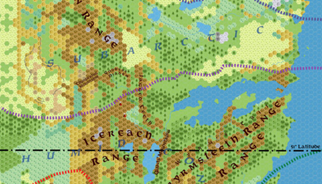
In April 2015’s issue #7 of Threshold Magazine, Simone published his most comprehensive take yet of Norwold. He actually created a set of four maps for his articles, of which this was the first, focusing on Norwold’s climate. The others concentrated on its names (the successor to his March 2007 Norwold 1.7 map), provinces, and regions.
I’m going to quote at length from Simone’s wonderful A Traveller’s Guide to Norwold article, which featured a great write-up of Norwold’s climate (Threshold #7 pages 8 and 10:
The climate of Norwold generally belongs to the continental band, up to the Great Bay included. The region is characterized by a wide seasonal variation of temperature, ranging from severely cold winters to hot summers, and a high degree of precipitation year-round. Snow is the norm at the height of the winter season, and usually may fall between late autumn and early spring, while in the summer rains tend to occur as thunderstorms. In the isles of the Strand, seasonal temperature variation tends to be narrower, with warm summers and cool winters and precipitations as abundant as on the mainland.
North of the Great Bay, climate turns subarctic, with a huge temperature variation between the long winter months that feature a below-freezing temperature (which can last even 5-7 months per year), and the warm but short summers. The soil is mostly characterized by the permafrost phenomenon, allowing only for hardy plant species, conifer trees, and taiga-type forests to survive. Near the coasts and at the southern boundary of this climate band, winters are milder and the permafrost does not occur, so the soil is better suited for agriculture here. In the subarctic areas, precipitations are low during the year and most of them occur during the fall, but they still allow for a snow cover during winter.
North of the Landsplit River system and of the Autuasmaa Plain, the tundra climate prevails. The frigid temperature and the presence of permafrost year-round do not allow for the growth of trees here, and only moss, heath, and lichen are supported in this area. The tundra is characterized by two main seasons, featuring dark and very cold winters, and somewhat warmer summers, when the upper layer of permafrost melts, leaving the soil soggy and covering the land with small marshes, lakes, and ponds.
In the region’s highlands and mountains, climate tends to be colder than in the surrounding region. Mountain ranges usually have subarctic climate regardless of latitude, and are characterized by alpine tundra climate above the treeline, with huge glaciers and permanent snowfields occupying the highest peaks and mountaintops.
The map itself is the familiar Norwold hex map with only the most major terrain features marked — generally just the large mountain ranges. To this Simone added coloured climate lines with zones labelled in large blue letters. Removing the majority of labels was absolutely necessary, because Norwold’s map is otherwise far too crowded at this scale.
Fan-made Map by Simone Neri (April 2015)
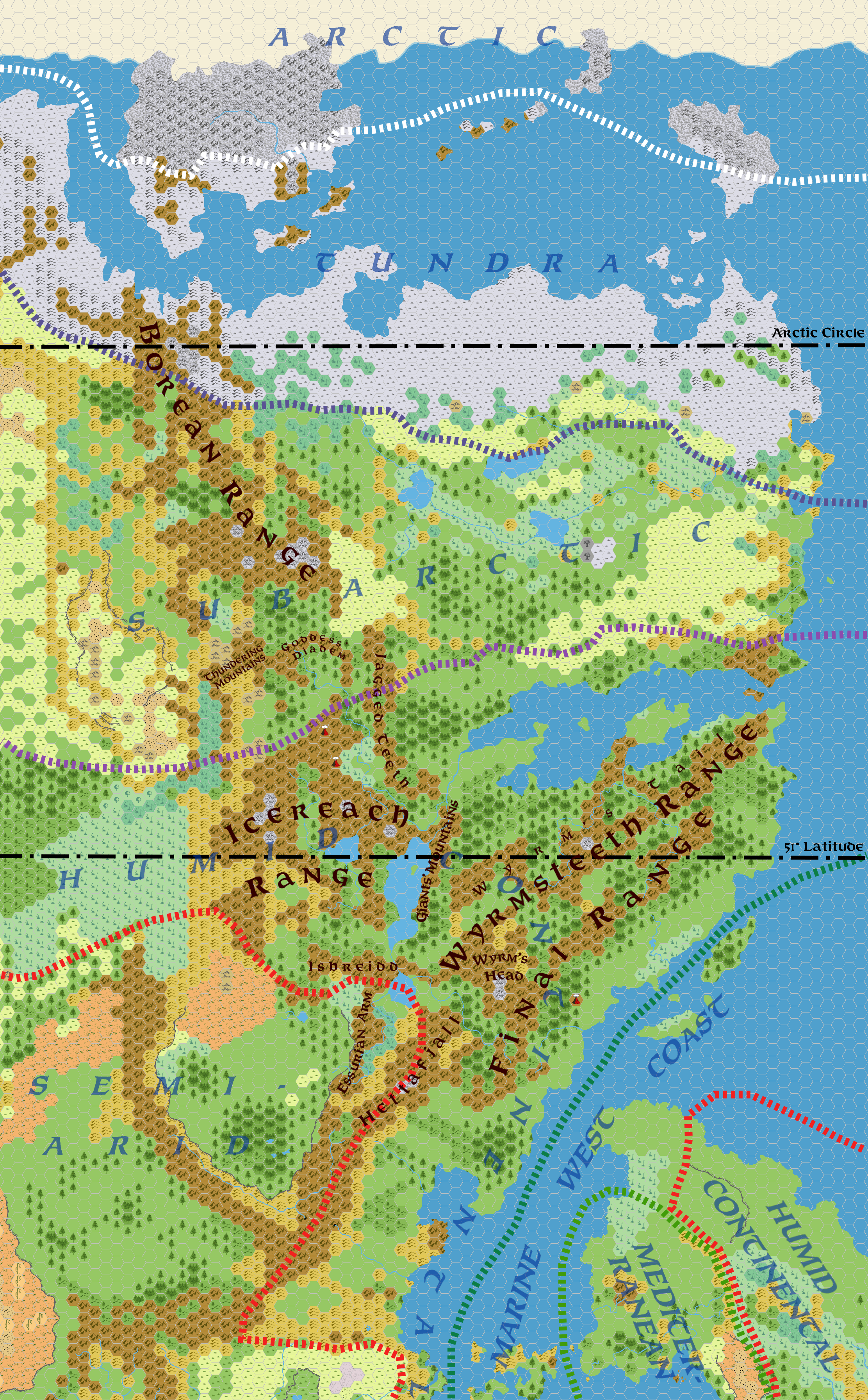
This is an original map created by one of Mystara’s excellent fan cartographers. For more information on the cartographer, including a gallery of all their maps, see also Appendix M: Mappers of Mystara.
Sources
Fan Sources
- Zendrolion’s Norwold, 24 miles per hex v1.7 (March 2007)
- A Traveller’s Guide to Norwold from Threshold Magazine #7 (April 2015)
References
- All of Simone’s maps at the Atlas of Mystara
- Simone’s entry in Appendix M: Mappers of Mystara (upcoming)
- Simone’s author page at the Vaults of Pandius
Chronological Analysis
This is a fan-made map. It was published in April 2015. The updated Atlas version of this map is not yet available. See also Appendix C for annual chronological snapshots of the area. For the full context of this map in Mystara’s publication history, see the upcoming Let’s Map Mystara 2015.
The following lists are from the Let’s Map Mystara project. Additions are new features, introduced in this map. Revisions are changes to previously-introduced features. Hex Art & Fonts track design elements. Finally, Textual Additions are potential features found in the related text. In most cases, the Atlas adopts these textual additions into updated and chronological maps.
Under Construction! Please check back again soon for updates.
Additions
- XXX —
Revisions
- XXX —
Hex Art & Fonts
- Hex Art —
- Fonts —