Zendrolion’s Mystara Precataclysmic
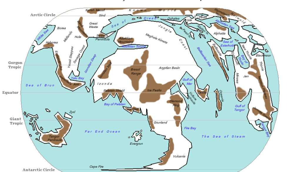
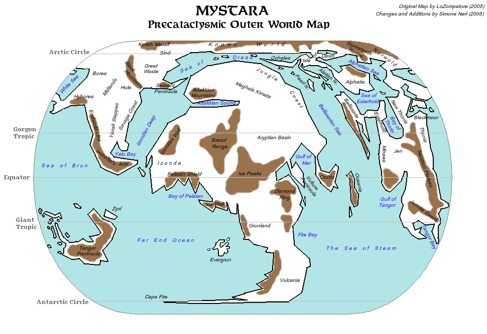
Simone shared a series of posts from his rakasta project in August 2008. He first introduced his adjusted version of Michele Carpita’s Precataclysmic Mystara map before going on to post maps based on that template to illustrate his timeline. The map below is his adjusted Precataclysmic map, which he introduced as follows:
Foreword About Precataclysmic Worldmap
Inconsistencies between canon references saying the Known World was under the arctic icecap before the Great Rain of Fire (BC 3000) and the Precataclysmic Outer World map found in Hollow World boxed set – which doesn’t feature the Known World under the arctic icecap – are already largely known. The basis of my works on ancient Mystara is the assumption that the Precataclysmic Outer World map of Hollow World boxed set has been wrongly rotated; instead, I use the following precataclysmic map drawn by LoZompatore, which has the Known World under arctic icecap:Mystara: Outer World Precataclysmic Map
Labels (obviously referring to AC 1000 locations) may help you in recognizing familiar locations in this otherwise weird-looking map. Brown areas indicate major mountain ranges.
As can be seen, and as we already knew from other contemporary work and posts, at this stage both Simone and Michele subscribed to the Known-World-as-North-Pole version of precataclysmic Mystara. This would change in later years.
Looking at the map, Simone took Michele’s map and added in brown areas for the mountains, as well as giving Evergrun its proper shape — which Michele later adopted in his own map of Evergrun. It seems likely that this was the original source of Evergrun’s shape.
He then added a whole series of labels, as he explained in the quote above, giving modern names to the ancient land and sea forms for convenience. This map served as the base for his Rakasta of Mystara series.
Fan-made Map by Simone Neri (August 2008)
This is an original map created by one of Mystara’s excellent fan cartographers. For more information on the cartographer, including a gallery of all their maps, see also Appendix M: Mappers of Mystara.
Sources
Fan Sources
- LoZompatore’s Precataclysmic Mystara (Evergrun) (August 2005)
- History and Evolution of Rakastas discussion thread at The Piazza (August 2008)
- History and Evolution of Rakastas at the Vaults of Pandius (August 2008)
References
- All of Simone’s maps at the Atlas of Mystara
- Simone’s entry in Appendix M: Mappers of Mystara (upcoming)
- Simone’s author page at the Vaults of Pandius
Chronological Analysis
This is a fan-made map. It was published in August 2008. The updated Atlas version of this map is not yet available. See also Appendix C for annual chronological snapshots of the area. For the full context of this map in Mystara’s publication history, see the upcoming Let’s Map Mystara 2008.
The following lists are from the Let’s Map Mystara project. Additions are new features, introduced in this map. Revisions are changes to previously-introduced features. Hex Art & Fonts track design elements. Finally, Textual Additions are potential features found in the related text. In most cases, the Atlas adopts these textual additions into updated and chronological maps.
Under Construction! Please check back again soon for updates.
Additions
- XXX —
Revisions
- XXX —
Hex Art & Fonts
- Hex Art —
- Fonts —