Zendrolion’s Brun 3000 BC
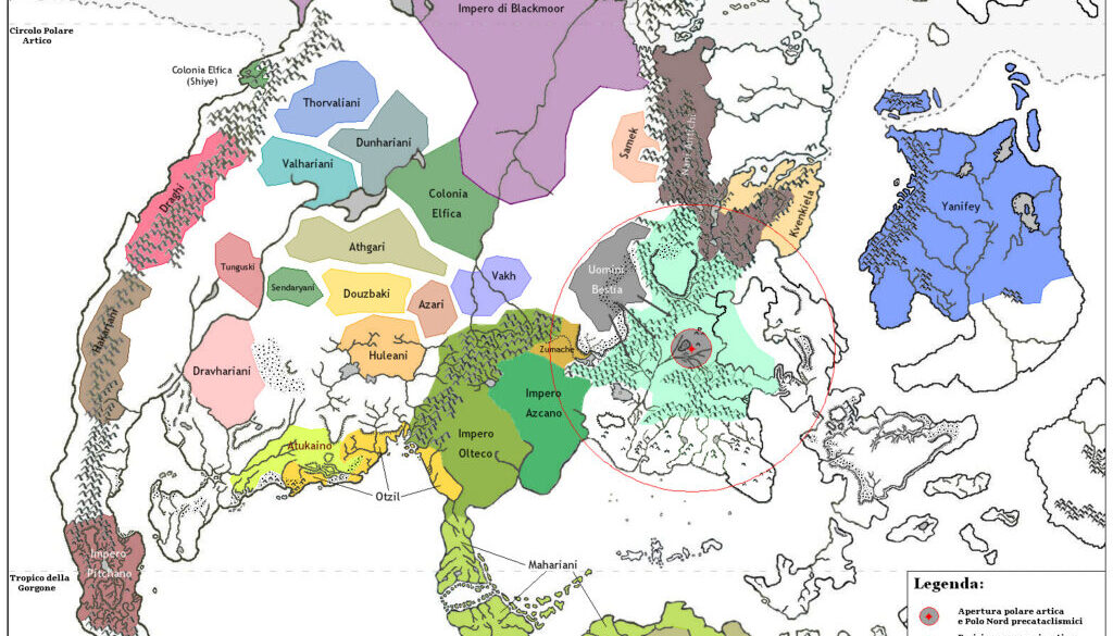
In April 2008, Átila made a thread at the MMB about Simone’s demographics project at the Italian MMB. The discussion developed into a debate about the position of the pre-cataclysmic North Pole, and Simone posted this map in one of his replies. Here’s how he introduced it:
Mystara’s pre-cataclysm projection used by LoZompatore in maps like this was done using an appropriate software with which he managed to obtain the “right” (according to most canon) position of Mystara’s landmasses before the GRoF. Therefore the position of the Arctic Circle should be also correct and located at about 66-degrees of latitude.
In this map, instead, I’ve simply tried to offer a sight of the pre-GRoF North Pole to show relative positions of peoples and races; obviously this map is not precise, as continental borders should be adjusted to pre-cataclysmic ones and moreover the Arctic Circle (red) has been traced in an approximate way, based more or less on the places it was passing throught in the previously linked map (the first with the whole pre-cataclysmic Mystara).
So, basically, I think the positioning of the Arctic Circle in those maps is rather correct. Perhaps Hugin is obtaining a different position because of the use of hex-grid maps for his projections (which may have caused some distortion); it may even be that LoZompatore’s map has some mistakes, but I’ve to discuss this point with him.
His positioning of the North Pole at that time was based on numerous references stating that the Known World area was previously the North Pole. As he stated earlier in the same thread, “there are clear references to the KW being the north pole in all the GAZ series and – absurdly – in HW itself. Moreover, the PWAs also have references about this. So, canon text is rather clear about KW’s position before the GRoF, while the only pre-cataclysmic canon map shows otherwise.”
The map (in Italian) shows cultures at the time just before the Great Rain of Fire, with a tentative Arctic Circle marked centred on the Known World area, and specifically with Ethengar as the North Pole.
There are a lot of interesting things on this map, including a conversion of Blackmoor’s location to fit it in Brun; various familiar cultures marked in their pre-Rain of Fire locations; and so on. Note that the subtitle labels the map as c. 3010 AC. The filename, however, labelled it as 3000 BC. Either way, the intent was clearly to place it right before the Great Rain of Fire.
Finally, I found this useful further explanation from Simone in a later thread, this time at The Piazza:
As you see, that map shows Brun’s geographical borders as they’re today – but that’s incorrect, becouse in BC 3,000, just before the Great Rain of Fire, they were much different (even the N-S direction was different). In fact, that map – which I did for my ethnography project on the Italian MMB – shows in which area of Brun the ancient populations were located if the continents’ borders had been then as today in AC 1,000; shortly put, it’s an anachronistic map, which shows populations (Blackmoor included) and borders which were never historically contemporaneous.
In fact, the “Impero di Blackmoor” label (that is, “Blackmoor Empire” in English) on that map actually marks Blackmoorian coloniest on Brun.
Fan-made Map by Simone Neri (April 2008)
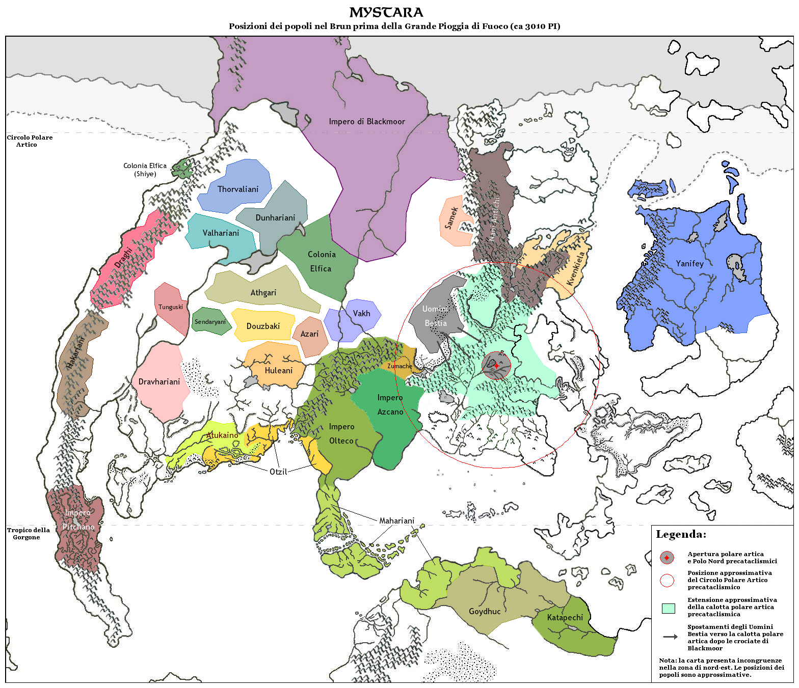
This is an original map created by one of Mystara’s excellent fan cartographers. For more information on the cartographer, including a gallery of all their maps, see also Appendix M: Mappers of Mystara.
Sources
Fan Sources
References
- All of Simone’s maps at the Atlas of Mystara
- Simone’s entry in Appendix M: Mappers of Mystara (upcoming)
- Simone’s author page at the Vaults of Pandius
Chronological Analysis
This is a fan-made map. It was published in April 2008. The updated Atlas version of this map is not yet available. See also Appendix C for annual chronological snapshots of the area. For the full context of this map in Mystara’s publication history, see the upcoming Let’s Map Mystara 2008.
The following lists are from the Let’s Map Mystara project. Additions are new features, introduced in this map. Revisions are changes to previously-introduced features. Hex Art & Fonts track design elements. Finally, Textual Additions are potential features found in the related text. In most cases, the Atlas adopts these textual additions into updated and chronological maps.
Under Construction! Please check back again soon for updates.
Additions
- XXX —
Revisions
- XXX —
Hex Art & Fonts
- Hex Art —
- Fonts —