
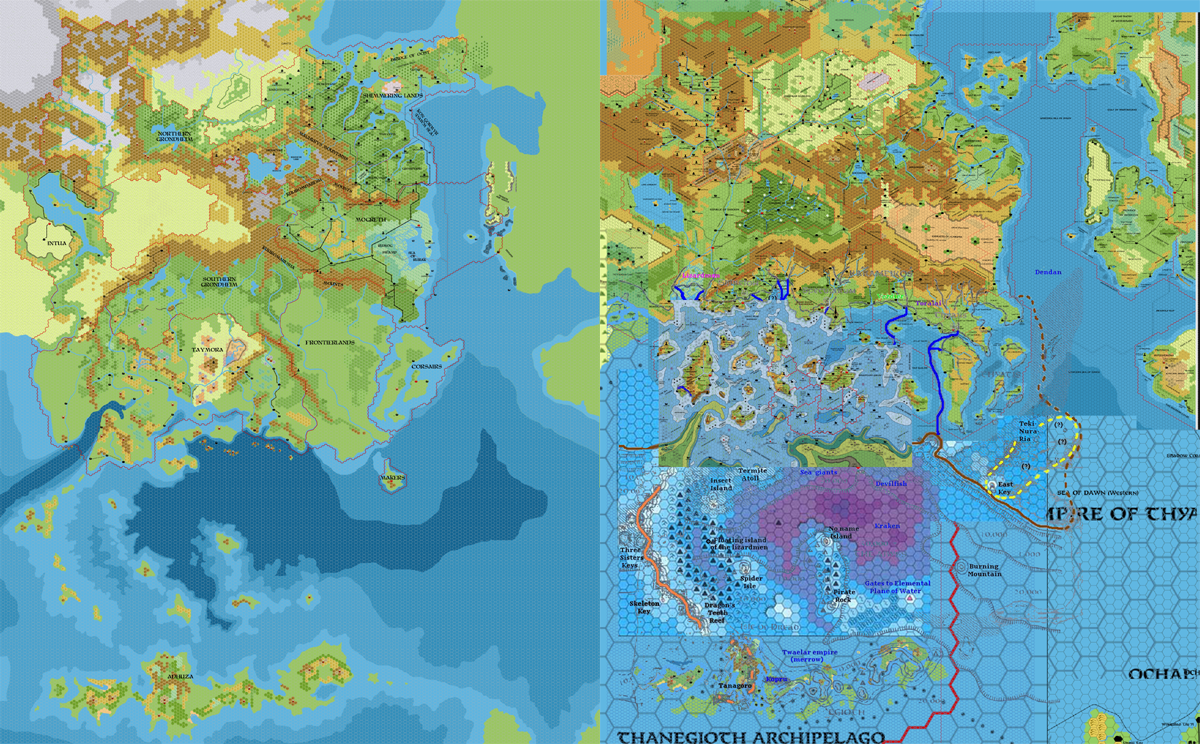
Chimpman’s Known World 2300 BC-1000 AC Comparison, 8 miles per hex
With his 2300 BC maps progressing, John worked up a side-by-side comparison of the mapped area. For 2300 BC, he used his 8 mile per hex map. For the modern view, he explained:
The modern Known World isn’t pretty, as I’ve cobbled together several maps to use as my baseline, but it should give you some idea.
In fact, he used a variation of his Master Template. However, the above described the first posted version, which is now lost; the file below is a newer update from four days later. He described his update:
There were quite a few changes that I had to make. Here’s what I did:
I took the 72mph, 24mph, and 8mph (the trail map) maps of the Isle of Dawn and Ochalea regions and combined them as best as I could. Of the 3 maps, two of them match up pretty well – the 8 and 24 mph maps. The 72 mph map has different shorelines and different landmass placement in a lot of cases -however it is the only map that has the Thanegioth included. If you take a look at the baseline map (on the right) you’ll see there are about 3 or 4 different placements for the archipelago. Thorf’s 72mph placement is the one at the lowermost right.
So… first, I’ve placed Ochalea further to the SE and drawn in the coastlines to match the modern day. Second I moved the Thanegioth more to the SE to be more in line with Thorf’s 72 mph map placement. Finally I redrew some of those southern contour lines. Let me know what you think.
Looking at the Master Template, the main addition was likely the 72 mile per hex map. Anyone who has worked with Mystara’s 72 mile per hex maps likely has alarm bells ringing in their head reading this, because unfortunately, the official 72 mile per hex maps were full of problems. Poor John talked about the multiple placements for the Thanegioth Archipelago, but the 72 mile per hex map is unlikely to help here — the better source would have been X1’s original 24 mile per hex Known World & Sea of Dread map.
This would come back to bite later in the project, causing a troublesome misalignment of Adhuza (i.e. the Thanegioth Archipelago).
Regardless of this, the comparison is a very powerful visual tool illustrating the drastic changes the Known World underwent between the two time periods.
Fan-made Map by John Calvin (July 2010)
This is an original map created by one of Mystara’s excellent fan cartographers. For more information on the cartographer, including a gallery of all their maps, see also Appendix M: Mappers of Mystara.
Sources
Fan Sources
- Chimpman’s Known World, 8 miles per hex Master Template (September 2009)
- Outer World: Taymora 2300 BC, 24 miles per hex discussion thread at The Piazza (July 2010)
References
- All of John’s maps at the Atlas of Mystara
- John’s entry in Appendix M: Mappers of Mystara (upcoming)
- John’s author page at the Vaults of Pandius
Chronological Analysis
This is a fan-made map. It was published in July 2010. The updated Atlas version of this map is not yet available. See also Appendix C for annual chronological snapshots of the area. For the full context of this map in Mystara’s publication history, see the upcoming Let’s Map Mystara 2010.
The following lists are from the Let’s Map Mystara project. Additions are new features, introduced in this map. Revisions are changes to previously-introduced features. Hex Art & Fonts track design elements. Finally, Textual Additions are potential features found in the related text. In most cases, the Atlas adopts these textual additions into updated and chronological maps.
Under Construction! Please check back again soon for updates.
")

")