
Chimpman’s Known World, 8 miles per hex Master Template
September 2009 saw a major turning point in John’s Mystara 2300 BC project, as he decided to switch from a 24 mile hex to an 8 mile hex base map. Up until that point, he had been working with 24 as the base, then developing chunks of the map at larger scale. But this hadn’t been working well. He explained in his post at The Piazza:
I began the project by mapping the BC 2300 Known World at 24mph, and then started picking off chunks to remap at 8mph. That’s when I stumbled on a problem. Basically there are errors in my BC 2300 24mph map on the southern coast of Brun (Taymora’s coastline), that I’m just not happy with. At this point I realized that what I really needed to do was go back to the drawing board and extend the map to the south so that it encompasses the Thanegioth Archipelago.
The other thing I realized was that I should be creating my master map at 8mph, and then working back to the 24mph (or greater) maps. It just ends up being less hassle this way. So to start off I scoured the Vaults for maps that I could use as a baseline, and found these three:
Known World and Sea of Dread 8 miles per hex by Mark Howard current as of 08 September 2006.
Maps of the Known World, 8 miles per hex by Thorfinn Tait, from The Piazza posted 24 March 2009.
Maps of the Sea of Dread Submerged Lands, 8 miles per hex, by Thorfinn Tait from The Piazza posted 02 August 2008.
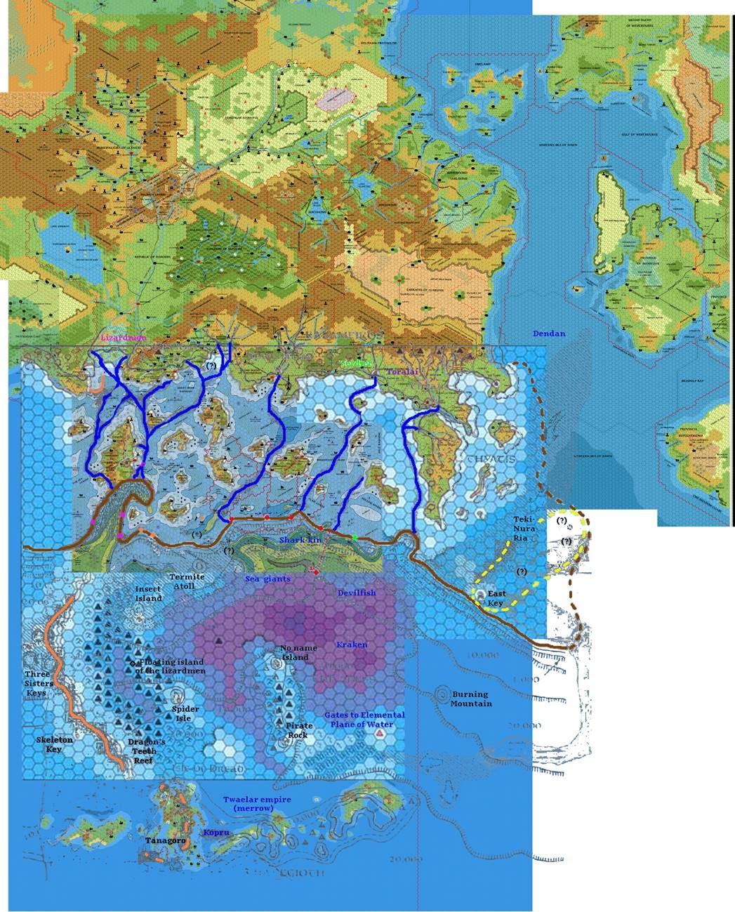
You can see all of these maps overlaid together below, along with Michele Carpita’s Sea of Dread and X7’s underwater map. John then drew lines to represent the contours of the lands of ancient Taymora, using the ocean depths and landforms as a guide.
This became a key research map to guide John’s project going forward.
Fan-made Map by John Calvin (September 2009)
This is an original map created by one of Mystara’s excellent fan cartographers. For more information on the cartographer, including a gallery of all their maps, see also Appendix M: Mappers of Mystara.
Sources
Fan Sources
References
- All of John’s maps at the Atlas of Mystara
- John’s entry in Appendix M: Mappers of Mystara (upcoming)
- John’s author page at the Vaults of Pandius
Chronological Analysis
This is a fan-made map. It was published in September 2009. The updated Atlas version of this map is not yet available. See also Appendix C for annual chronological snapshots of the area. For the full context of this map in Mystara’s publication history, see the upcoming Let’s Map Mystara 2009.
The following lists are from the Let’s Map Mystara project. Additions are new features, introduced in this map. Revisions are changes to previously-introduced features. Hex Art & Fonts track design elements. Finally, Textual Additions are potential features found in the related text. In most cases, the Atlas adopts these textual additions into updated and chronological maps.
Under Construction! Please check back again soon for updates.
")
")
")