
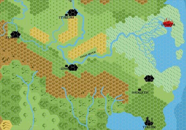
Chimpman’s Mogreth 2300 BC, 8 miles per hex City Comparison
This map provided a snapshot into the city placement thinking of John Calvin and Geoff Gander as they designed Mogreth, in late August 2009. Geoff had just posted an altered map of Ylaruam showing the positions of Mogreth’s chief settlements. John replied on The Piazza:
Here is an overlay of the city placement on the 24mph map with the city placements at 8mph specified in your above map.
Isshum, Theliir, and Teshos are spot on. It looks like Ithkesh and Ussur may be off by a hex (either on the original map or the new map). Ssugath I’ve placed directly over the modern position of Tameronikas. That one is way off from your original positioning in the 24mph map.
Frankly I like the idea that Ssugath = Tameronikas, but we’ll have to make some changes to the map if we want it to be so. I suppose that the swamp could be extended all the way to the hills.
Most of these placements stuck — all but Theliir in the south, which they moved another 24 mile hex south.
The slight misalignment here was likely due to the inherent misalignment between 8 and 24 mile per hex maps of this region of the Known World that originated in GAZ1 and GAZ2.
Fan-made Map by John Calvin (August 2009)
This is an original map created by one of Mystara’s excellent fan cartographers. For more information on the cartographer, including a gallery of all their maps, see also Appendix M: Mappers of Mystara.
Sources
Fan Sources
- Chimpman’s Taymora 2300 BC, 24 miles per hex Cities (August 2009)
- Outer World: Mogreth 2300 BC, 8 miles per hex discussion thread at The Piazza (August 2009-August 2023)
References
- All of John’s maps at the Atlas of Mystara
- John’s entry in Appendix M: Mappers of Mystara (upcoming)
- John’s author page at the Vaults of Pandius
Chronological Analysis
This is a fan-made map. It was published in August 2009. The updated Atlas version of this map is not yet available. See also Appendix C for annual chronological snapshots of the area. For the full context of this map in Mystara’s publication history, see the upcoming Let’s Map Mystara 2009.
The following lists are from the Let’s Map Mystara project. Additions are new features, introduced in this map. Revisions are changes to previously-introduced features. Hex Art & Fonts track design elements. Finally, Textual Additions are potential features found in the related text. In most cases, the Atlas adopts these textual additions into updated and chronological maps.
Under Construction! Please check back again soon for updates.
")
")
")