Zendrolion’s Alfheim, 8 miles per hex Overlay
Shortly after the Piazza opened in 2008, I began posting map threads in the Geographical Mapping subforum of the Mystara board. Simone was kind enough to post in many of those threads, providing a great deal of information on things that could be added to each map.
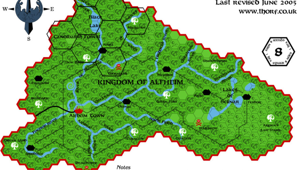
This overlay of a 3 mile per hex grid on an early version of my Alfheim, 8 miles per hex map was part of one of those posts. He first posted it in the Alfheim thread, then later reposted it in the map thread for Darokin. It was paired with a similar treatment in reverse for O2’s Emerlas, 3 miles per hex map, with the aim of placing the Emerlas in the northern Canolbarth.
This literal interpretation of the maps posed a problem, as the presence of the town of Ainsun didn’t really fit with the isolated borderland feel of the Emerlas. Simone proposed a different solution:
Now, the main problem is that the description of the Emerlas matches that of a border region, where the humanoid warbands easily penetrate and where there are also some non-elven settlements. IF one wanted to keep the size of O2’s Emerlas, he would also have to explain just HOW humanoid bands could penetrate so much near Ainsun without any help arriving from Alfheim’s government.
Therefore, a solution could be to reduce the size of O2’s map so that the Emerlas areas could fit into the uppermost 24-m hex of Alfheim – that is on the area north of Blackwater River on the 8-m map.
In the event, I chose not to touch this rather thorny issue, and as a result the Atlas of Mystara Updated map of Alfheim does not include the Emerlas or any of O2’s features.
Fan-made Map by Simone Neri (July 2008)
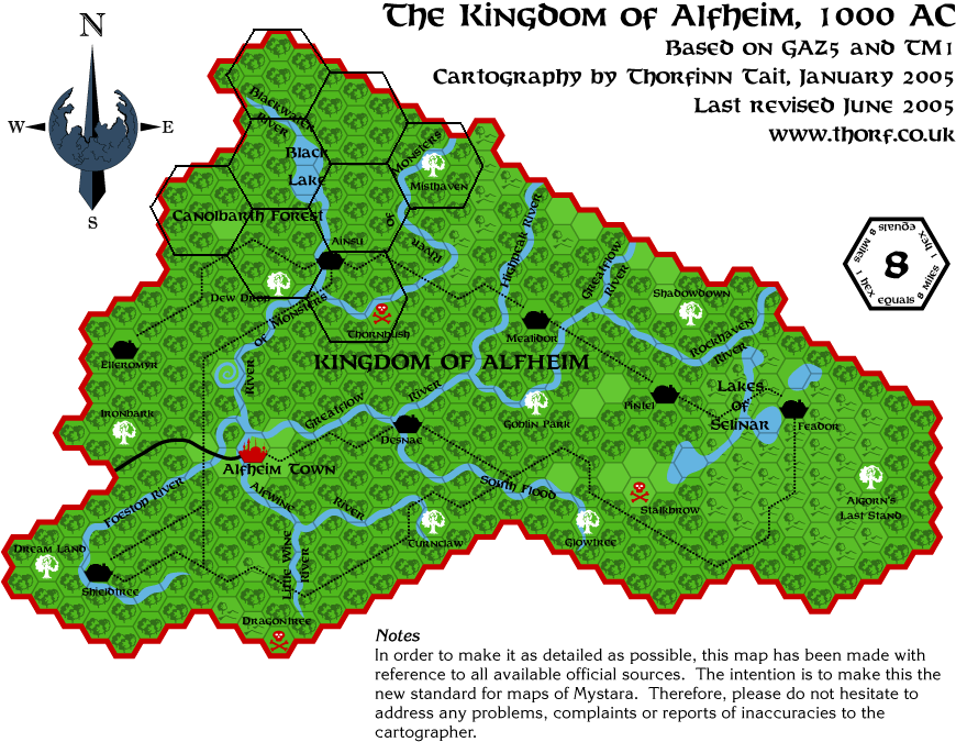
This is an original map created by one of Mystara’s excellent fan cartographers. For more information on the cartographer, including a gallery of all their maps, see also Appendix M: Mappers of Mystara.
Sources
- GAZ5 The Elves of Alfheim (1988) (PDF at DriveThruRPG)
Fan Sources
- Atlas of Mystara (2005-present)
- Outer World: Alfheim, 8 miles per hex discussion thread at The Piazza (July 2008)
References
- All of Simone’s maps at the Atlas of Mystara
- Simone’s entry in Appendix M: Mappers of Mystara (upcoming)
- Simone’s author page at the Vaults of Pandius
Chronological Analysis
This is a fan-made map. It was published in July 2008. The updated Atlas version of this map is not yet available. See also Appendix C for annual chronological snapshots of the area. For the full context of this map in Mystara’s publication history, see the upcoming Let’s Map Mystara 2008.
The following lists are from the Let’s Map Mystara project. Additions are new features, introduced in this map. Revisions are changes to previously-introduced features. Hex Art & Fonts track design elements. Finally, Textual Additions are potential features found in the related text. In most cases, the Atlas adopts these textual additions into updated and chronological maps.
Under Construction! Please check back again soon for updates.
Additions
- XXX —
Revisions
- XXX —
Hex Art & Fonts
- Hex Art —
- Fonts —