
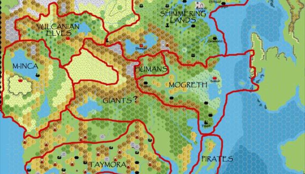
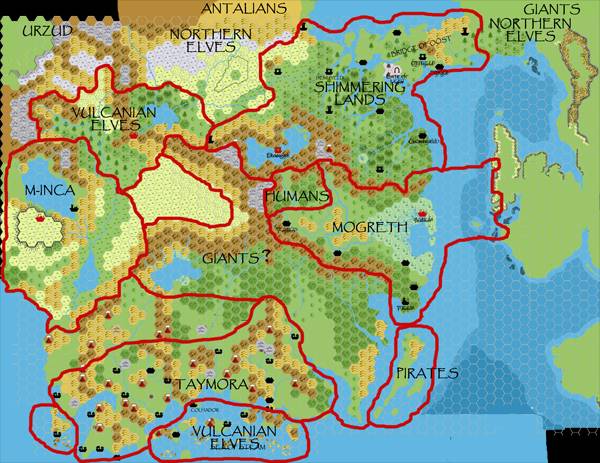
Chimpman’s Known World 2300 BC, 24 miles per hex Borders
As with many of John’s early maps, the earliest version of this map is missing. He first posted it on 1st April 2009, where he mentioned lots of things not yet marked:
I’ve been working on the Shimmering Lands map for a while now, so I thought I’d throw some other borders out there to try and get a sense of where everyone is at.
There followed a great discussion brainstorming the nations that would have been around at the time, and the next day John posted an updated version (the map below) which included all of these nations.
– updated coastlines on IoD using Thorf’s TM2 trail map as a guideline
– added in borders for pirates, the human kingdom near Mogreth, extended Mogreth out to Redstone, and created a border for the “Gandhar” giants
– added labels for Urzud, Antalians, and possibly northern giants of IoD as place markers (even though their actual territory is off map)I’m not sure how much territory the Gandhar (or whatever we will call them) giants will take. For now I’ve marked all the way from Rockhome to the shores of Thyatis. There are also still empty areas between the M-Inca and Taymora, and in the Alfheim region.
This gives us a wonderful overview of the state of John’s project at the time, as well as a preview of what it would become. Within a few years, he would have most of these nations mapped, in varying states of development.
Fan-made Map by John Calvin (April 2009)
This is an original map created by one of Mystara’s excellent fan cartographers. For more information on the cartographer, including a gallery of all their maps, see also Appendix M: Mappers of Mystara.
Sources
- GAZ5 The Elves of Alfheim (1988) (PDF at DriveThruRPG)
- GAZ6 The Dwarves of Rockhome (1988) (PDF at DriveThruRPG)
- GAZ10 The Orcs of Thar (1989) (PDF at DriveThruRPG)
- Hollow World Campaign Set (1990) (PDF at DriveThruRPG)
- PC3 The Sea People (1990) (PDF at DriveThruRPG)
- HWR2 Kingdom of Nithia (1991) (PDF at DriveThruRPG)
Fan Sources
- Chimpman’s Moadreg 2300 BC, 24 miles per hex (February 2009)
- Chimpman’s Mogreth 2300 BC, 24 miles per hex (March 2009)
- Outer World: Taymora 2300 BC, 24 miles per hex discussion thread at The Piazza (March 2009)
References
- All of John’s maps at the Atlas of Mystara
- John’s entry in Appendix M: Mappers of Mystara (upcoming)
- John’s author page at the Vaults of Pandius
Chronological Analysis
This is a fan-made map. It was published in April 2009. The updated Atlas version of this map is not yet available. See also Appendix C for annual chronological snapshots of the area. For the full context of this map in Mystara’s publication history, see the upcoming Let’s Map Mystara 2009.
The following lists are from the Let’s Map Mystara project. Additions are new features, introduced in this map. Revisions are changes to previously-introduced features. Hex Art & Fonts track design elements. Finally, Textual Additions are potential features found in the related text. In most cases, the Atlas adopts these textual additions into updated and chronological maps.
Under Construction! Please check back again soon for updates.
21 June 2026 @ 6:38 pm
32 of March is always an unusual date to start anything. Are you sure there really was a first version from that date? Or might this one be the actual first version