
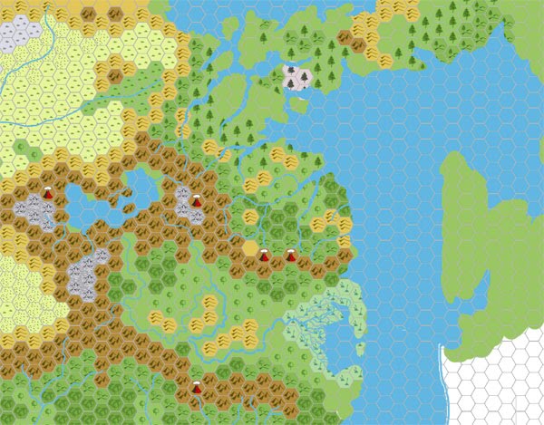
Chimpman’s Moadreg 2300 BC, 24 miles per hex
John posted this map at The Piazza at the same time as his Moadreg 1000 BC map. Together they traced this region of the Known World from the present day back to a time not long after the Great Rain of Fire. This was his first map of Mystara in 2300 BC, so it all started here. Unfortunately the original version is lost to us; this second version dates to just a few days after the original.
In his thread at The Piazza, John explained:
This first map is of Mystara (KW region) in BC 2300. The main differences that you can see are an extension (eastward) of present day Ylaruam, the absence of the Land of Black Sands in Ethengar, a land bridge that stretches from the KW through the Northern Reaches and connects to the Isle of Dawn, and various other changes involving lakes and rivers and such (which are totally incomplete).
The land bridge I’m calling the Bridge of Oost (from which Oostland will be derived in later centuries), and I make reference to that in various places in previous posts. That gray portion on the Bridge of Oost is the area around the Gate of Light, and the location from which the Wasting disease is centered. The idea is that as the dwarves gain in power the radiance extends further and further into neighboring lands. This will eventually be the downfall of the dwarves as their neighbors finally band together to destroy them.
This was the beginning of an incredible project, delving into Mystara’s history and bringing a past era to life in a vibrant new setting.
Fan-made Map by John Calvin (February 2009)
This is an original map created by one of Mystara’s excellent fan cartographers. For more information on the cartographer, including a gallery of all their maps, see also Appendix M: Mappers of Mystara.
Sources
- B10 Night’s Dark Terror (1986) (PDF at DriveThruRPG)
- GAZ5 The Elves of Alfheim (1988) (PDF at DriveThruRPG)
- GAZ6 The Dwarves of Rockhome (1988) (PDF at DriveThruRPG)
- GAZ10 The Orcs of Thar (1989) (PDF at DriveThruRPG)
- Hollow World Campaign Set (1990) (PDF at DriveThruRPG)
- HWR2 Kingdom of Nithia (1991) (PDF at DriveThruRPG)
Fan Sources
- Chimpman’s Known World 1000 BC, 24 miles per hex v2 (September 2008)
- Mystara 2300 BC – The Shimmering Lands discussion thread at The Piazza (February 2009)
- Mystara 2300 BC – The Shimmering Lands discussion thread at The Piazza (February 2009)
References
- All of John’s maps at the Atlas of Mystara
- John’s entry in Appendix M: Mappers of Mystara (upcoming)
- John’s author page at the Vaults of Pandius
Chronological Analysis
This is a fan-made map. It was published in February 2009. The updated Atlas version of this map is not yet available. See also Appendix C for annual chronological snapshots of the area. For the full context of this map in Mystara’s publication history, see the upcoming Let’s Map Mystara 2009.
The following lists are from the Let’s Map Mystara project. Additions are new features, introduced in this map. Revisions are changes to previously-introduced features. Hex Art & Fonts track design elements. Finally, Textual Additions are potential features found in the related text. In most cases, the Atlas adopts these textual additions into updated and chronological maps.
Under Construction! Please check back again soon for updates.

")
")