Chimpman’s Dwarven Migrations BC 3000 to BC 2300 v2
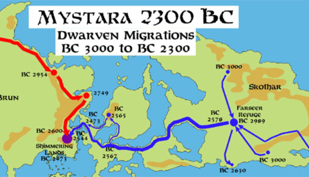
With his Mystara 2300 BC world map now complete, John immediately moved forward with an update to the Dwarven Migrations map. He switched in the new map as the base terrain, replacing the placeholder 1000 AC landforms. This map was to be featured in the PDF for Mystara 2300 BC, so it was an important piece of work. John outlined his thinking in a post at The Piazza:
- I am now using the updated BC 2300 World Map.
- I changed the route of the BC 2578 Skotharian migration. Originally it followed the BC 2630 migration and crossed the southern land bridge to Bellisaria, but I think the new route is shorter… and the BC 2630 route would have been considered unluck (at best) or cursed, since those dwarves were never heard from again.
- I’m also toying with the idea that the western migration fractured south of Alphatia, sending some dwarves north to Hurgon. Those dwarves would later come to the call of their brethren in BC 2473, abandoning Hurgon for their new home in the Shimmering Lands. During the Rockhome era, some dwarves would “rediscover” these lands, naming them Denwarf Hurgon (in honor of their ancestral hero, and the original founder).
It wasn’t just the underlying terrain that John changed — he also thoroughly expanded the map itself, making it far more detailed than the first draft version.
Fan-made Map by John Calvin (August 2012)
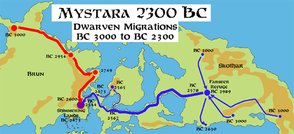
This is an original map created by one of Mystara’s excellent fan cartographers. For more information on the cartographer, including a gallery of all their maps, see also Appendix M: Mappers of Mystara.
Sources
Fan Sources
- Chimpman’s Dwarven Migrations BC 3000 to BC 2300 v1 (June 2012)
- [Nation] The Shimmering Lands discussion thread at The Piazza (January 2009-March 2013)
References
- All of John’s maps at the Atlas of Mystara
- John’s entry in Appendix M: Mappers of Mystara (upcoming)
- John’s author page at the Vaults of Pandius
Chronological Analysis
This is a fan-made map. It was published in August 2012. The updated Atlas version of this map is not yet available. See also Appendix C for annual chronological snapshots of the area. For the full context of this map in Mystara’s publication history, see the upcoming Let’s Map Mystara 2012.
The following lists are from the Let’s Map Mystara project. Additions are new features, introduced in this map. Revisions are changes to previously-introduced features. Hex Art & Fonts track design elements. Finally, Textual Additions are potential features found in the related text. In most cases, the Atlas adopts these textual additions into updated and chronological maps.
Under Construction! Please check back again soon for updates.