
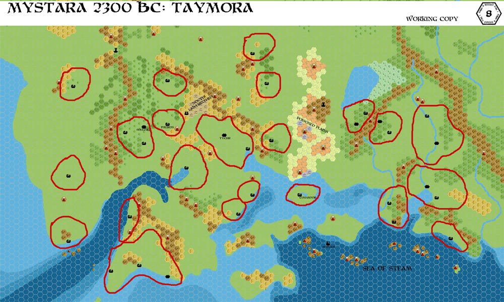
Chimpman’s Taymora 2300 BC, 8 miles per hex Borders
This was the last in a set of three maps John made upon returning to his Mystara 2300 BC project in March 2010. The sister map of Taymora Cities, it was also an update to an earlier map from a couple of days before; that first version is now lost to us. While the cities map focused on settlements, this one concentrated on borders for the city-states making up Taymora. John’s introduction to the map at The Piazza was as follows:
Here is a map of Taymora with some rough borders drawn in. I’m trying to estimate what the territories of each of the city states might be based on placement of the cities themselves and the terrain.
I’m purposely not drawing in the island state borders, since I think it’s likely they won’t be fully formed during this period. A few of the territories encompass more than one city – these are the larger city states who have managed to conquer some of their neighbors either through force or diplomacy. The rest of the city states are composed of single cities.
Let me know what you think. Are the territories too big? Too small? Should there be more splits, or more merges? I think it’s feasible to get somewhere between 11 and 15 city states, depending on how we break them out.
Those comments all describe the lost first version of the map. The Cities map followed the next day, then the second version of Borders (the map below) the day after that. John explained the update:
I’m playing around with a swampy area near the deep water pool of the kna, and I might try expanding it to see what it looks like – but I also want to play up the volcanic activity of the area.
I’ve updated the Borders. There are now around 20 distinct territories.
We can guess the content of the first version from this combined with the Cities map for comparison. Most likely, the biggest difference was that this map added more borders. John had also been developing the area of badlands labelled the Poisoned Plains.
Fan-made Map by John Calvin (March 2010)
This is an original map created by one of Mystara’s excellent fan cartographers. For more information on the cartographer, including a gallery of all their maps, see also Appendix M: Mappers of Mystara.
Sources
- PC3 The Sea People (1990) (PDF at DriveThruRPG)
Fan Sources
- Chimpman’s Taymora 2300 BC, 24 miles per hex Cities (August 2009)
- Chimpman’s Taymora 2300 BC, 8 miles per hex v2 (September 2009)
- World of Mystara 2300 BC discussion thread at The Piazza (March 2009-August 2010)
- Chimpman’s Taymora 2300 BC, 8 miles per hex Cities (March 2010)
References
- All of John’s maps at the Atlas of Mystara
- John’s entry in Appendix M: Mappers of Mystara (upcoming)
- John’s author page at the Vaults of Pandius
Chronological Analysis
This is a fan-made map. It was published in March 2010. The updated Atlas version of this map is not yet available. See also Appendix C for annual chronological snapshots of the area. For the full context of this map in Mystara’s publication history, see the upcoming Let’s Map Mystara 2010.
The following lists are from the Let’s Map Mystara project. Additions are new features, introduced in this map. Revisions are changes to previously-introduced features. Hex Art & Fonts track design elements. Finally, Textual Additions are potential features found in the related text. In most cases, the Atlas adopts these textual additions into updated and chronological maps.
Under Construction! Please check back again soon for updates.

")
