")
Chimpman’s Known World 2300 BC, 8 miles per hex v2
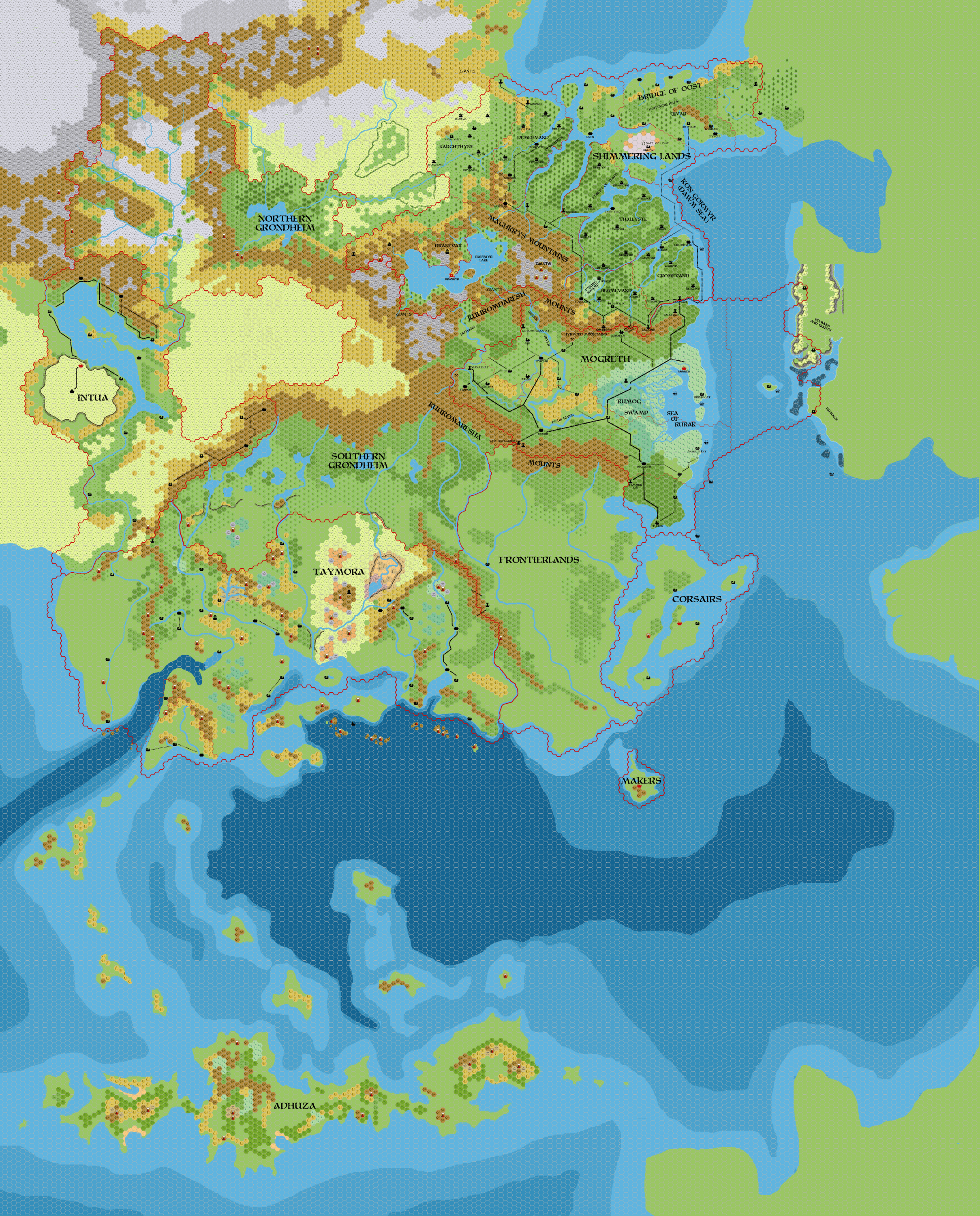
As with so many of these old files, the original posted first version of this map is now lost to us. John posted it to his World of Mystara 2300 BC thread at The Piazza at the end of March 2010, noting, “I know it’s a slow process, but the BC 2300 Known World is starting to take shape.” There was little discussion of the state of the map at that time, so we can only guess at what it really looked like.
He posted this second version (below) just a few months later, in the Outer World: Taymora map thread in July 2010, commenting:
It’s still not complete, but it is getting a lot closer. Rough borders for everything but Adhuza, Antalians, Deep Elves (who are underground anyway), and Urzud are drawn in.
From this we can assume that the first version had few (or no) borders marked. Otherwise, it was most likely rather similar.
Now, let’s talk about the map itself. John had gone through a large number of iterations to get this far in his project, including individual maps for the Shimmering Lands, Mogreth, the Frontierlands, Taymora, and most recently Intua. All of these were incorporated into this map, but there were also new details, such as the Corsairs, Grondheim, and of course the borders themselves. The isle of the Makers had also been labelled.
All in all, the production of this map was a major step forward for the project, and this second version brought it one step closer to completion. John would revisit it again to include updates from newer maps over the next few years.
Fan-made Map by John Calvin (July 2010)
This is an original map created by one of Mystara’s excellent fan cartographers. For more information on the cartographer, including a gallery of all their maps, see also Appendix M: Mappers of Mystara.
Sources
- PC3 The Sea People (1990) (PDF at DriveThruRPG)
Fan Sources
- Chimpman’s Known World, 8 miles per hex Master Template (September 2009)
- Chimpman’s Known World, 8 miles per hex Coastlines (September 2009)
- Chimpman’s Known World, 8 miles per hex Coastlines with Cities (September 2009)
- Chimpman’s Known World 2300 BC, 8 miles per hex Working Coastlines v1 (September 2009)
- Chimpman’s Known World 2300 BC, 8 miles per hex Working Coastlines v2 (September 2009)
- Historical Mapping in the KW and Sea of Dread discussion thread at The Piazza (September 2009-October 2010)
- World of Mystara 2300 BC discussion thread at The Piazza (March 2009-August 2010) v1 original post
- Outer World: Taymora 2300 BC, 24 miles per hex discussion thread at The Piazza (September 2008-August 2010) v2 original post
References
- All of John’s maps at the Atlas of Mystara
- John’s entry in Appendix M: Mappers of Mystara (upcoming)
- John’s author page at the Vaults of Pandius
Chronological Analysis
This is a fan-made map. It was published in July 2010. The updated Atlas version of this map is not yet available. See also Appendix C for annual chronological snapshots of the area. For the full context of this map in Mystara’s publication history, see the upcoming Let’s Map Mystara 2010.
The following lists are from the Let’s Map Mystara project. Additions are new features, introduced in this map. Revisions are changes to previously-introduced features. Hex Art & Fonts track design elements. Finally, Textual Additions are potential features found in the related text. In most cases, the Atlas adopts these textual additions into updated and chronological maps.
Under Construction! Please check back again soon for updates.


")