")
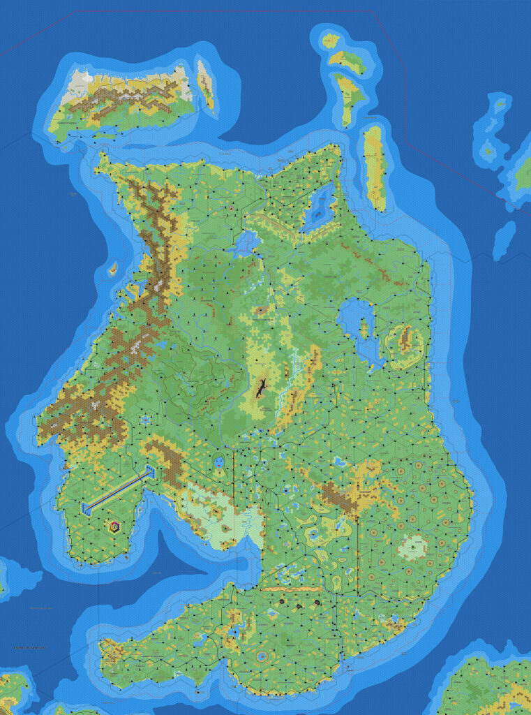
Ramelin’s Alphatia, 8 miles per hex v2
Following his Alphatian Empire mega-map in January and the first version of his standalone Alphatia map in March, Jose created a this second standalone map of Alphatia in August 2018. It’s just as impressive as the first one.
His focus this time was on updates to surrounding lands and sea depths; mainland Alphatia itself remained almost identical. The most major change was the addition of Qeodhar v2, and there were also quite large changes to the sea depths to its south, especially around the coasts of Frisland and in the Alphatian Sea. The other big change was the deletion of Bellissaria from the southeastern corner of the map. This was likely caused by its being shifted slightly southwards in the Western Skothar map, thus pushing it just off the edge of this map.
Jose also cropped the map tighter around Alphatia, showing less of the surrounding lands. This was very likely an attempt to make the huge map more manageable; I later did the exact same thing with my own map of Alphatia.
Fan-made Map by Jose Ignacio Ramos Lomelin (August 2018)
This is an original map created by one of Mystara’s excellent fan cartographers. For more information on the cartographer, including a gallery of all their maps, see also Appendix M: Mappers of Mystara.
Sources
- Dawn of the Emperors (1989) (PDF at DriveThruRPG)
- Bruce Heard’s Alphatia (2012-2013)
- etc.
Fan Sources
- Ramelin’s Frisland, 8 miles per hex (February 2015)
- Ramelin’s Blackheart, 8 miles per hex (January 2016)
- Ramelin’s Imperial Territories, 8 miles per hex v1 (February 2016)
- Ramelin’s Bellissaria, 8 miles per hex v2 (March 2017)
- Ramelin’s Sea of Dawn Islands, 8 miles per hex (March 2017)
- Ramelin’s Norzee, 8 miles per hex (September 2017)
- Ramelin’s Isle of Dawn, 8 miles per hex (November 2017)
- Ramelin’s Alphatian Empire, 8 miles per hex (January 2018)
- Ramelin’s Shiye-Lawr, 8 miles per hex (March 2018)
- Ramelin’s Imperial Territories, 8 miles per hex v2 (March 2018)
- Ramelin’s Alphatia, 8 miles per hex v1 (August 2018)
References
- All of Jose’s maps at the Atlas of Mystara
- Jose’s entry in Appendix M: Mappers of Mystara (upcoming)
- Jose’s author page at the Vaults of Pandius
Chronological Analysis
This is a fan-made map. It was published in August 2018. The updated Atlas version of this map is Alphatia, 8 miles per hex. See also Appendix C for annual chronological snapshots of the area. For the full context of this map in Mystara’s publication history, see the upcoming Let’s Map Mystara 2018.
The following lists are from the Let’s Map Mystara project. Additions are new features, introduced in this map. Revisions are changes to previously-introduced features. Hex Art & Fonts track design elements. Finally, Textual Additions are potential features found in the related text. In most cases, the Atlas adopts these textual additions into updated and chronological maps.
Under Construction! Please check back again soon for updates.
Additions
- Settlements —
Revisions
- Settlements —
Hex Art & Fonts
- Hex Art — Ramelin Mystara standard.
- Fonts — Bell MT (major geographic and all water labels), Bell Centennial (all other labels), Feinen (titling).

")

")