")
Ramelin’s Western Minaea, 8 miles per hex v1
Perhaps inspired by his recent mapping of the neighbouring regions of Alphatia, Bellissaria, and Esterhold, Jose made another foothold in Skothar with this map of Western Minaea. It almost goes without saying at this point that this was the first time for anyone to create an 8 mile per hex map of this area — yet another first for Ramelin Mystara. Jose explained his concept of Minaea on the post at his DeviantArt gallery:
Minaea is BIG. I can’t imagine it as a country, but as a region with allied (or conflicting) city states (Polikratos). The most important and prominent is the Minaea Polikratos, which is the name used by Alphatians for the whole region.
In this first version, the western coast was reasonably well detailed, especially opposite Bellissaria. But there was far less detail in the interior, as well as many unnamed settlements scattered throughout the map. The primary source appears to be Francesco Defferrari’s Minaea, 24 mile per hex map, although Jose added a lot of new details of his own when converting to 8 miles per hex.
Jose would revisit this map for another pass a year later.
Fan-made Map by Jose Ignacio Ramos Lomelin (March 2018)
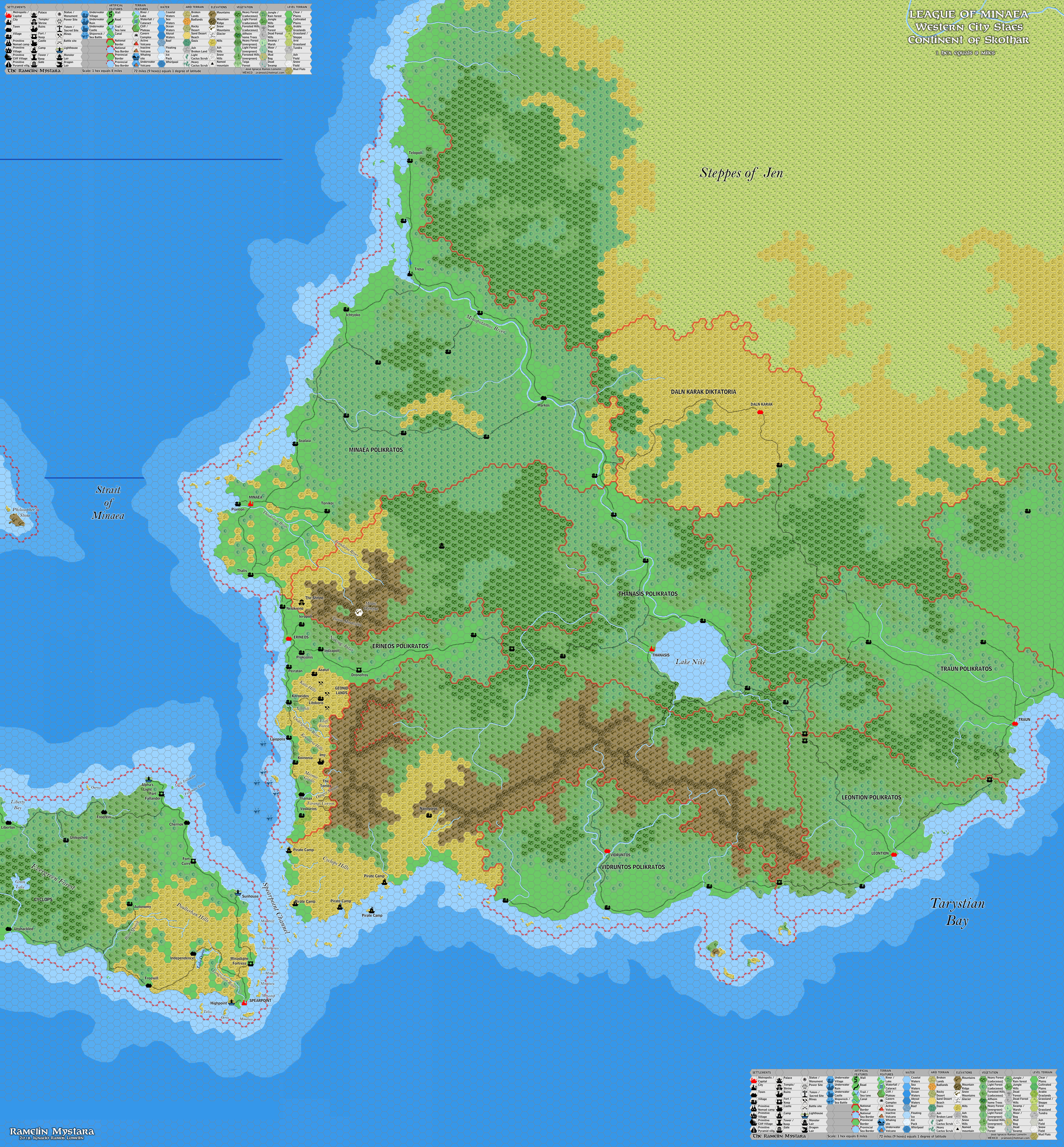
This is an original map created by one of Mystara’s excellent fan cartographers. For more information on the cartographer, including a gallery of all their maps, see also Appendix M: Mappers of Mystara.
Sources
- Dawn of the Emperors (1989) (PDF at DriveThruRPG)
- Hollow World Campaign Set (1990) (PDF at DriveThruRPG)
- Poor Wizard’s Almanac (1992) (PDF at DriveThruRPG)
- Poor Wizard’s Almanac III (1994) (PDF at DriveThruRPG)
Fan Sources
- Thibault’s Minaea, 24 miles per hex (April 2002)
- Sturm’s Minaea, 24 miles per hex (March 2011)
References
- All of Jose’s maps at the Atlas of Mystara
- Jose’s entry in Appendix M: Mappers of Mystara (upcoming)
- Jose’s author page at the Vaults of Pandius
Chronological Analysis
This is a fan-made map. It was published in March 2018. The updated Atlas version of this map is not yet available. See also Appendix C for annual chronological snapshots of the area. For the full context of this map in Mystara’s publication history, see the upcoming Let’s Map Mystara 2018.
The following lists are from the Let’s Map Mystara project. Additions are new features, introduced in this map. Revisions are changes to previously-introduced features. Hex Art & Fonts track design elements. Finally, Textual Additions are potential features found in the related text. In most cases, the Atlas adopts these textual additions into updated and chronological maps.
Under Construction! Please check back again soon for updates.
Additions
- Settlements —
Revisions
- Settlements —
Hex Art & Fonts
- Hex Art — Ramelin Mystara standard.
- Fonts — Bell MT (major geographic and all water labels), Bell Centennial (all other labels), Feinen (titling).
")

")