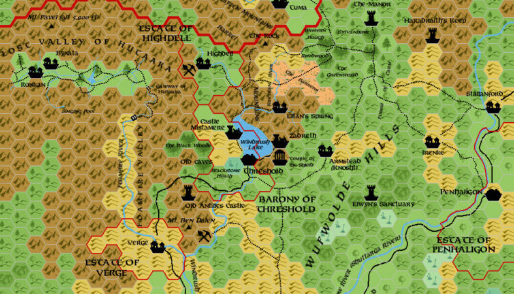
Zendrolion’s Threshold Area, 2.7 miles per hex
After his Denagoth migration maps in early 2006, Simone returned mid-year with a new map: the town of Threshold and its surroundings in northern Karameikos. Again, he posted it to the Mystara Message Board, where he commented:
I made a map of Threshold region, based on all (to my knowledge) canon sources. Here’s the map; I apologize for the odd scale, but I simply used a x3 zoom on the GAZ1 map.
I’ve used a style as similar as possible to Thorf’s one for the map.
He went on to give a detailed rundown of the sites appearing on the map. It’s a great description, and so it’s worth noting all of these here:
I’ve incorporated in the map all the material of the B adventures, accordingly to the informations given in B1-9.
The B8 area has been put in the more favorable position “north of Threshold” (B1-9, which is the most recent source about the area – the original B8’s suggested placement was instead west of Threshold): rather distant from large communities and in hilly hexes (it would have been rather difficult indeed to put the area in mountainous hexes). The trails from the B8 map have been connected to other logical spots in the map above. I think it could be reasonable to connect Tuma and The Manor with other Darokin features thought trails that cross the mountain range through showed mountain passes. Moreover, I’ve assumed River Krevilan from B8 to be the same river that goes north from Eltan’s Springs (from KKoA).For the ferries farms in B10 I’ve used the “posthouse” symbol from GAZ12 – I’ve intended it to be any building smaller than a village (an isolated inn, farm, etc.) other than a keep, castle, etc. Obviously, the map isn’t intended to show every single posthouse, farm of isolated inn, but only the more important (or known) ones.
The Windrush Lake’s sizes have been reduced; according the measures given in KKoA, the lake would be over three 8-miles-hexes long in N-S direction, and over one in W-E direction. Becouse the lake couldn’t be so large (it’s not even showed in the GAZ1 map), I’ve reduced it to fit within a single 8-miles-hex.
You’ll see borders of minor fiefdoms; I’ve assumed that the fiefdoms whose borders were not showed in GAZ1 map to be one 8-miles-hex or smaller in size.
Last but not least, I’ve tried to keep the Lost Valley of Hutaaka in the position where B10 puts it. So I’ve not moved it westward, as GAZ1 suggests. With some minor adjustments, I’ve managed to keep it within Karameikos without altering B10 too much.
Finally, he provided a point by point description of the major locations. It’s a gold mine of distilled information on the area.
All in all, Simone took every single piece of information he could find for the area and adapted it into the map. His placements weren’t always literal; instead, he worked to fit everything into the area in a logical manner. Thus, for example, B8’s Tuma is located in a clearing in the mountains to the north rather than its recommended official location — where it would overlap with the mountains and the Foamfire Valley.
Simone’s work on this map has been highly influential ever since, with numerous other fan maps referring back to his ideas. John Calvin even created a PC version of the map that hid DM-only information.
Fan-made Maps by Simone Neri (August 2006)
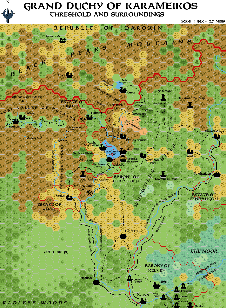
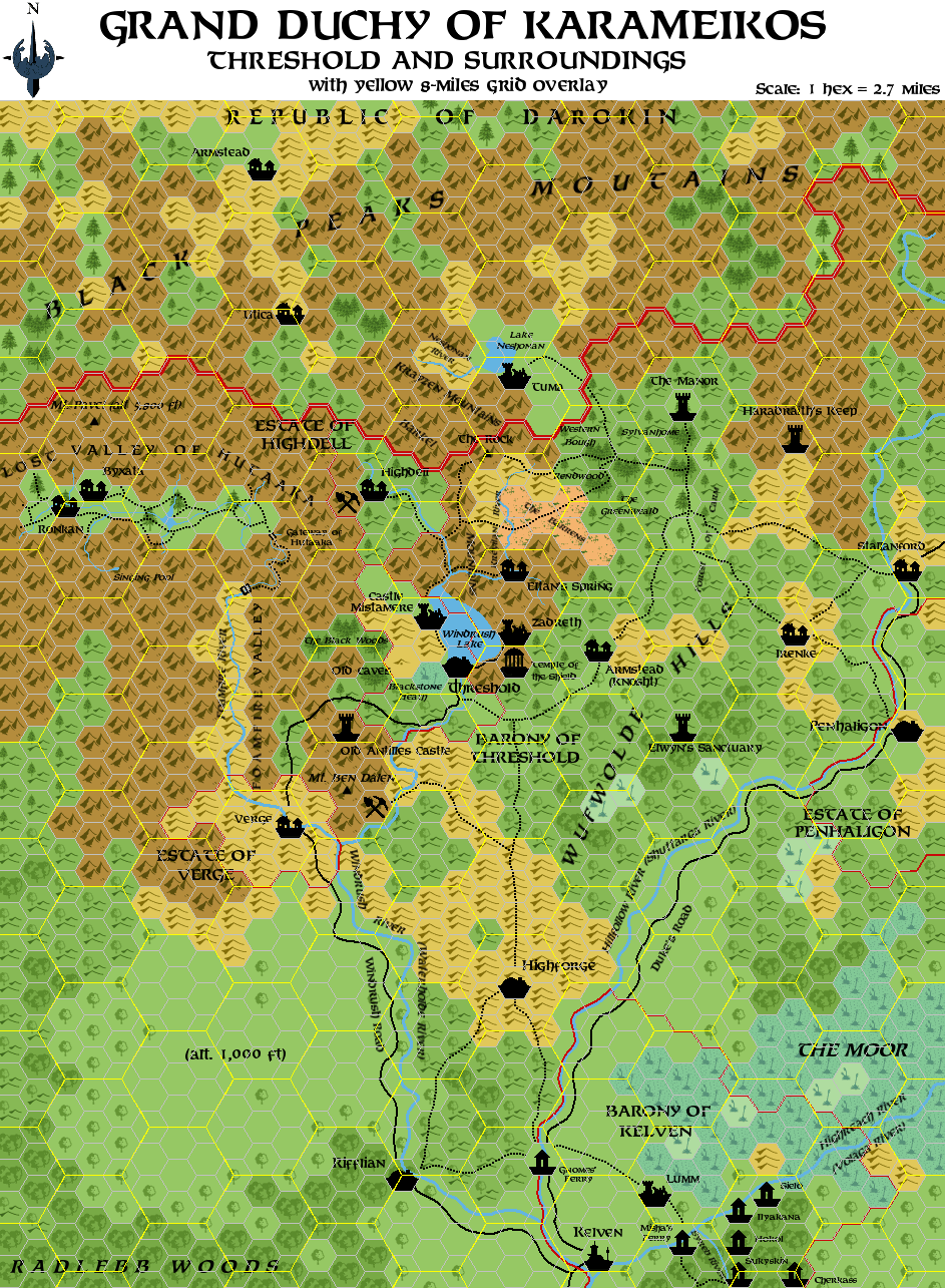
This is an original map created by one of Mystara’s excellent fan cartographers. For more information on the cartographer, including a gallery of all their maps, see also Appendix M: Mappers of Mystara.
Sources
- Basic Rules Set (1983) (PDF at DriveThruRPG)
- Expert Rulebook (1983) (PDF at DriveThruRPG)
- B1 In Search of the Unknown (1978) (PDF at DriveThruRPG)
- B2 The Keep on the Borderlands (1979) (PDF at DriveThruRPG)
- B3 Palace of the Silver Princess (1981) (PDF at Vaults of Pandius)
- B3 Palace of the Silver Princess (1981) (PDF at DriveThruRPG)
- B4 The Lost City (1982) (PDF at DriveThruRPG)
- B5 Horror on the Hill (1983) (PDF at DriveThruRPG)
- B6 The Veiled Society (1984) (PDF at DriveThruRPG)
- B7 Rahasia (1984) (PDF at DriveThruRPG)
- B8 Journey to the Rock (1984) (PDF at DriveThruRPG)
- B9 Castle Caldwell and Beyond (1985) (PDF at DriveThruRPG)
- B10 Night’s Dark Terror (1986) (PDF at DriveThruRPG)
- B11 King’s Festival (1989) (PDF at DriveThruRPG)
- B12 Queen’s Harvest (1989) (PDF at DriveThruRPG)
- B1-9 In Search of Adventure (1987) (PDF at DriveThruRPG)
- AC11 Book of Wondrous Inventions (1987) (PDF at DriveThruRPG)
- X12 Skarda’s Mirror (1987) (PDF at DriveThruRPG)
- GAZ1 The Grand Duchy of Karameikos (1987) (PDF at DriveThruRPG)
- GAZ5 The Elves of Alfheim (1988) (PDF at DriveThruRPG)
- The Tainted Sword (October 1992)
- The Dragon’s Tomb (April 1993)
- Ransom, Dungeon #42 (July 1993)
- The Fall of Magic (October 1993)
- Karameikos: Kingdom of Adventure (1994) (PDF at DriveThruRPG)
- Hail the Heroes (1994) (PDF at DriveThruRPG)
Fan Sources
References
- All of Simone’s maps at the Atlas of Mystara
- Simone’s entry in Appendix M: Mappers of Mystara (upcoming)
- Simone’s author page at the Vaults of Pandius
Chronological Analysis
This is a fan-made map. It was published in August 2006. The updated Atlas version of this map is not yet available. See also Appendix C for annual chronological snapshots of the area. For the full context of this map in Mystara’s publication history, see the upcoming Let’s Map Mystara 2006.
The following lists are from the Let’s Map Mystara project. Additions are new features, introduced in this map. Revisions are changes to previously-introduced features. Hex Art & Fonts track design elements. Finally, Textual Additions are potential features found in the related text. In most cases, the Atlas adopts these textual additions into updated and chronological maps.
Under Construction! Please check back again soon for updates.
Additions
- XXX —
Revisions
- XXX —
Hex Art & Fonts
- Hex Art —
- Fonts —