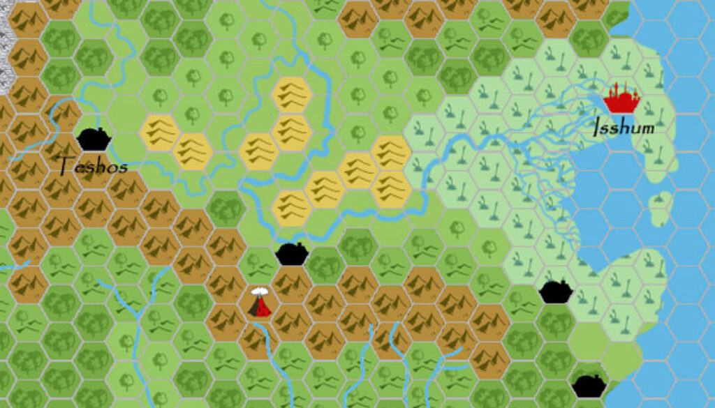
Chimpman’s Mogreth 2300 BC, 24 miles per hex
The next step in the evolution of John Calvin’s Mystara 2300 BC was this map of Mogreth. He first posted it at The Piazza in early March 2009, noting:
I placed some of the cities that you mentioned onto the BC 2300 map I’m working on. Theliir is on the site of Tel Akbir. Isshum is near to the location of Surra-Man-Raa, but not directly over the site. I also placed unnamed cities…
This version of the map is lost to us, as John updated it almost immediately, responding to feedback from Geoff Gander, who suggested:
I’d extend the swamp back to the easternmost line of hills – so two hexes further west, and I’d convert about half of the eastern light forest hexes into swamps, too. Leave the dense forest, though. The capital was intended to be Isshum, and the largest temple was located at Teshos…
These changes are clearly visible in the version of the map below, which was an updated version from some days later. It appears that John decided to stick with this adjusted version of Mogreth. He later used it as a base to create his 8 mile per hex map of the region.
Thus, even this early on in the project, we could already see the lizard man nation in quite an advanced form.
Fan-made Map by John Calvin (March 2009)
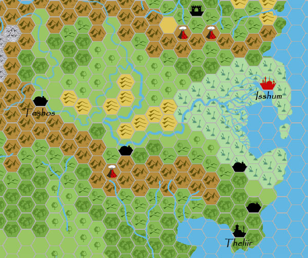
This is an original map created by one of Mystara’s excellent fan cartographers. For more information on the cartographer, including a gallery of all their maps, see also Appendix M: Mappers of Mystara.
Sources
- GAZ5 The Elves of Alfheim (1988) (PDF at DriveThruRPG)
- GAZ6 The Dwarves of Rockhome (1988) (PDF at DriveThruRPG)
- GAZ10 The Orcs of Thar (1989) (PDF at DriveThruRPG)
- Hollow World Campaign Set (1990) (PDF at DriveThruRPG)
- HWR2 Kingdom of Nithia (1991) (PDF at DriveThruRPG)
Fan Sources
- Mystara 2300 BC – The Shimmering Lands discussion thread at The Piazza (February 2009)
- Mystara 2300 BC – The Shimmering Lands discussion thread at The Piazza (February 2009)
- Chimpman’s Moadreg 2300 BC, 24 miles per hex (February 2009)
References
- All of John’s maps at the Atlas of Mystara
- John’s entry in Appendix M: Mappers of Mystara (upcoming)
- John’s author page at the Vaults of Pandius
Chronological Analysis
This is a fan-made map. It was published in March 2009. The updated Atlas version of this map is not yet available. See also Appendix C for annual chronological snapshots of the area. For the full context of this map in Mystara’s publication history, see the upcoming Let’s Map Mystara 2009.
The following lists are from the Let’s Map Mystara project. Additions are new features, introduced in this map. Revisions are changes to previously-introduced features. Hex Art & Fonts track design elements. Finally, Textual Additions are potential features found in the related text. In most cases, the Atlas adopts these textual additions into updated and chronological maps.
Under Construction! Please check back again soon for updates.